


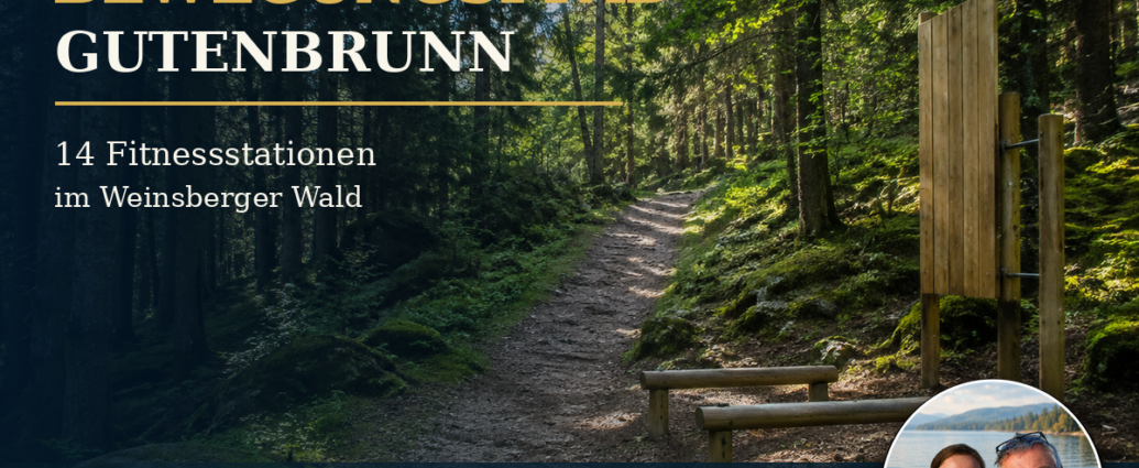
The Exercise Trail Gutenbrunn combines hiking, nature, and simple exercises at 14 stations set in a varied landscape. It also offers a clearly marked route through the town and the forests surrounding Gutenbrunn. The blend of town and nature makes the trail appealing.
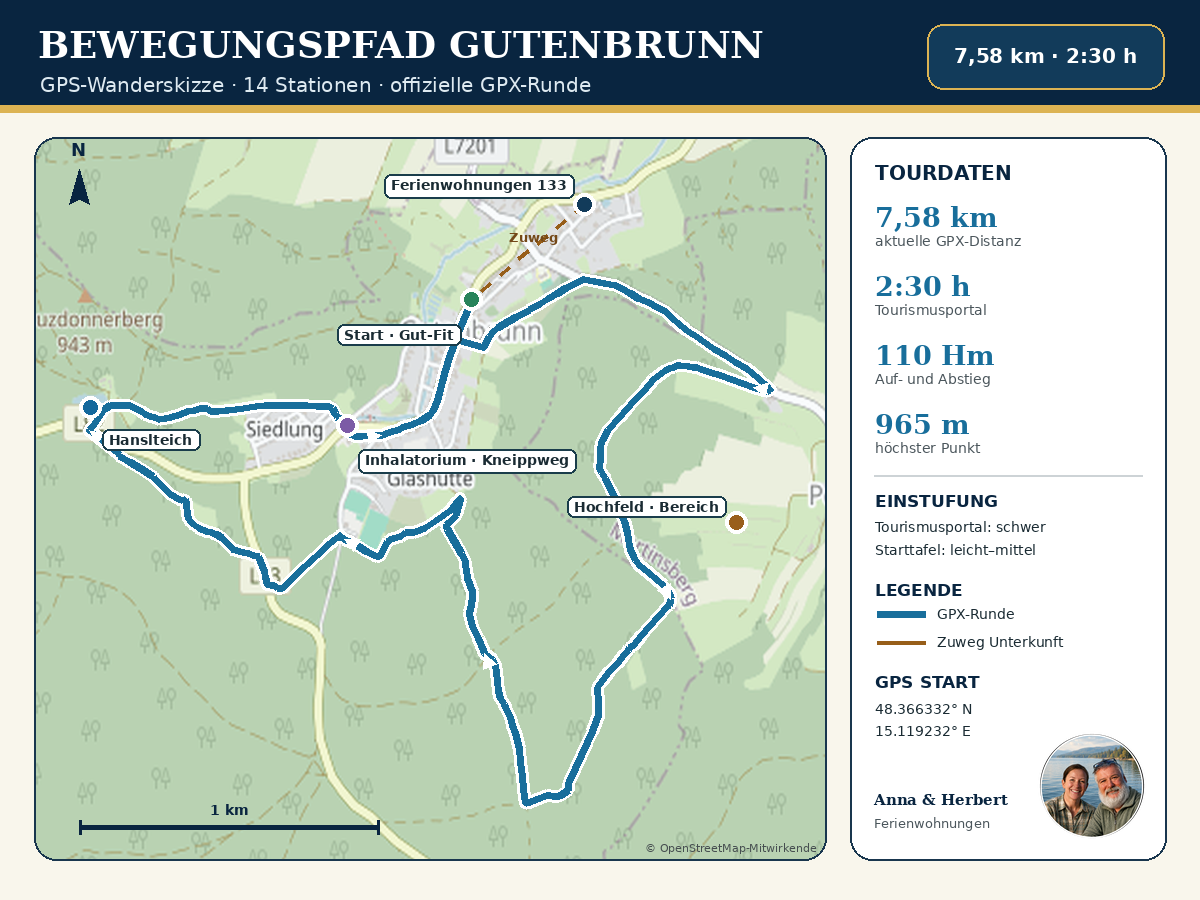
The loop trail begins at the Gut-Fit fitness center next to the town hall. It winds through the town and up into the forests surrounding Gutenbrunn. It reaches the Hochfeld area. It then returns via the sports field, Hansl pond, Inhalation Room and back along the Kneipp Trail. This keeps the route manageable and easy to follow.
The trail is not just a short stroll past a few pieces of exercise equipment. The GPX route is 7.58 kilometers long. It has an elevation gain and loss of 110 meters. Waldviertel Tourismus estimates the walking time to be about two and a half hours.
Anyone who makes a point of using the exercise stations along the Gutenbrunn Fitness Trail should take breaks. They’ll also enjoy the final stop at the Inhalatorium and should plan to spend more time there.
For guests staying at the Gutenbrunn vacation apartments, the Gutenbrunn Fitness Trail is especially convenient. What’s more, the official starting point is just a short walk from the accommodations at Gutenbrunn 133. You can leave your car parked, and once you’ve finished the loop, you’ll be back at your vacation apartment in no time.
The Gutenbrunn Fitness Trail at a Glance
- Description: A loop trail with 14 exercise and fitness stations
- Start and finish: Gut-Fit Fitness Center next to the Gutenbrunn Municipal Office
- Distance according to the current tourism portal: 7.58 kilometers
- Calculated length of the current GPX file: approximately 7.57 kilometers
- Previous information on the starting board and the town's website: 7.3 kilometers
- Walking time according to the tourism website: approximately 2 hours and 30 minutes
- Walking time according to the sign at the trailhead: about 3 hours
- Ascent and descent according to the tourism portal: 110 meters in elevation each
- Elevation gain according to the starting board: 142 meters
- Lowest point: 855 meters
- Highest point: 965 meters
- Fitness level according to the tourism portal: 4 out of 6
- Features: Loop hike with scenic views
- Strollers: According to the official tour description, this route is not suitable for strollers
- Points of interest: former railroad tracks, Hochfeld, the old Kirchensteig trail, the sports field, Hanslteich, the inhalatorium, and the Kneipp trail
- Recommended gear: sturdy shoes, weather-appropriate clothing, water, a cell phone, and hiking poles if needed
The current tour description from Waldviertel Tourismus was updated on August 3, 2026. The GPX file provided there serves as the basis for our hiking map and the current distance information.
What Makes the 14 Stops Special
Along the fitness trail, a hike is complemented by exercise stations. According to the official trail description, the first exercises begin above the village near the former railroad tracks. The exercises are illustrated on signs and labeled with difficulty levels. This allows everyone to decide for themselves which exercise best suits their flexibility, strength, and current fitness level.
The stations are not intended to be a competition. You don’t have to do every exercise or reach a certain number of repetitions. The appeal lies instead in the variety: walking for a few minutes, pausing at a station, moving your body mindfully, and then continuing your walk at your own pace.
The official documents list the 14 stations by number but do not publish a complete list of exercise names and specific GPS coordinates. For this reason, we do not describe any supposedly exact station exercises, as they may look different on site. The signs along the trail and their current instructions are always authoritative.
Start at Gut-Fit and the municipal office
The official starting and finishing point of the Gutenbrunn Walking Trail is at the Gut-Fit fitness center next to the municipal office. From there, the trail first passes by the church and heads uphill toward the former railroad tracks. Even on this first section, you gain elevation and are treated to a beautiful view of Gutenbrunn.
Starting from the starting point, this loop is easy to combine with a visit to the town. The pilgrimage church, the castle, and Trucker House are nearby. If you walk the fitness trail in the morning, you can spend the rest of the day exploring other sights in Gutenbrunn or taking a quiet break at the vacation rental.
The parking lot at the municipal office is listed as a parking option in the official tour description. Guests staying at the apartments generally don't need it: There is a short path leading from the Gutenbrunn 133 vacation apartments to the starting point.
First exercises on the former railroad track
After the climb past the church, you’ll reach the area of the former railroad tracks. According to the tour description, the first fitness exercises begin here. The route then turns left, passes the cemetery, and follows the signs toward Poggschlag.
Especially at the beginning, it’s best to take it slow. When you try the exercises at each station, you engage different muscle groups than you would during normal walking. A short warm-up, controlled movements, and breaks between exercises are therefore recommended.
The signs indicate the exercise and its level of difficulty. Movements should only be performed to the extent that they feel safe and pain-free. If you have any health limitations or feel unsure, it’s better to skip a station and simply enjoy the hike as a nature walk.
Through the forest toward Poggschlag
After the cemetery, the route leads into the forest. The 14 stations are spread out along the path, combining exercise with the experience of nature. Amid spruce trees, mixed woodland, moss-covered rocks, and quiet forest paths, the atmosphere here is quite different from that of a traditional fitness trail.
After it rains, the forest floor can be damp, soft, or slippery. Roots, rocks, and uneven sections require caution. Good shoes with treads are therefore more important than specialized athletic clothing.
At the end of this section of the trail, the route turns right onto a farm road. From there, it continues uphill to the Hochfeld.
This longer climb is a major reason why, despite its manageable distance, the trail should not be considered a completely easy walk.
Up to the Hochfeld
Hochfeld is one of the most scenic sections of the fitness trail.
In addition, the route gains even more elevation.
It reaches a maximum length of 965 meters along its entire course.
In addition, depending on the weather and visibility, open areas offer a sweeping view of the surrounding area.
Forest edges contribute to this view.
Anyone participating in the exercises at the stations should plan for extra energy reserves for the climb. It’s often a good idea to take a short break here to drink some water. In warm weather, it’s advisable to bring plenty of water, even if the tour starts right in town and is less than eight kilometers in total.
The Hochfeld is also known for the hiking trail of the same name, No. 44. However, the fitness trail follows its own longer loop. Therefore, the two trails should not be confused based on their names or route lengths.
Back to Gutenbrunn via the old Kirchensteig trail
From Hochfeld, the fitness trail leads back toward Gutenbrunn via the old Kirchensteig. According to the official description, there is a shortcut available within the town: If you turn right, you can return to the starting point.
This shortcut is useful if participants no longer have enough energy to complete the entire loop after the Hochfeld section, if the weather changes, or if some participants want to return early. Since the route and signage may be subject to change on-site, participants should check the signposts to confirm the turn-off.
If you want to complete the entire loop, keep to the left and continue along the path past the sports field. Only then does the final major section toward Hanslteich and the Inhalatorium begin.
From the sports field through the last stretch of woods
After the sports field, the trail leads through a wooded area once again. This section clearly illustrates why the fitness trail is not suitable for strollers. The combination of forest trails, changes in elevation, and a road crossing requires sure-footedness and caution.
Finally, you'll cross State Route L83. Please pay special attention to traffic here and keep an eye on children as well as Dogs close to you in good time. After crossing, you'll reach the area near Hanslteich.
Hanslteich is a lovely landmark and a great spot for a short break. Those who are already familiar with the pond from another walk in Gutenbrunn will encounter it on the fitness trail as part of a longer, more vigorous route.
A Relaxing End to the Day at the Inhalatorium and Kneipp Trail
From Hanslteich, the trail leads back to Gutenbrunn. Toward the end, you’ll come to the playground and the inhalatorium with the Kneipp path. The official guide recommends ending the hike here at a leisurely pace.
This finale fits the character of the fitness trail particularly well. After the exercises and the forest sections, you can slow down, take a break, and stretch your legs. Whether and how the inhalatorium or individual facilities can be used depends on the season, weather, and current operating information.
The route then takes you back through the town to the starting point at Gut-Fit. If you're staying at the Gutenbrunn vacation rentals, you'll reach your lodging after a short additional walk.
7.3 or 7.58 kilometers? An explanation of the official figures
Various official figures for the walking trail have been published. The town’s website and the information board at the trailhead list 7.3 kilometers, approximately 10,000 steps, about three hours of walking time, and 142 meters of elevation gain. The information board classifies the trail as easy to moderate.
In contrast, the tourism portal, updated on August 3, 2026, lists 7.58 kilometers, about two and a half hours, and 110 meters of elevation gain and loss. The current GPX file contains 340 waypoints and calculates to approximately 7.57 kilometers. For this reason, we are using the newer GPX version for the map and tour data.
Such discrepancies are not unusual for a hiking route. Differences in measurement methods, map data, and the most recent updates can affect the distance and elevation gain. When planning your own hike, it’s more important to allow enough time for warm-ups, breaks, and the actual trail conditions.
Easy, medium, or hard?
The official descriptions also differ when it comes to the level of difficulty. The older information board describes the difficulty as easy to moderate. Waldviertel Tourismus classifies the current tour as difficult and rates its fitness requirement as a 4 on a six-point scale.
In practical terms, this means: The route is not technically an alpine hike, but it includes uphill sections, forest trails, uneven terrain, a road crossing, and the added physical challenge of the exercises. Those who complete all the stations will find the loop more challenging than those who simply hike.
The difficulty rating should therefore not be off-putting, but it should be taken seriously. A slow pace, sturdy shoes, and avoiding unsuitable exercises will make the day more enjoyable. After heavy rain, or in snow or ice, the difficulty can increase significantly.
Is the fitness trail suitable for older guests?
For active and steady-footed older guests, the fitness trail can offer a varied vacation experience. The stations allow for individual choices, and the loop can be walked at a leisurely pace without any pressure to perform. It’s especially enjoyable not to feel obligated to complete every exercise, but rather to consciously alternate between physical activity, the forest, and breaks.
Keep in mind the distance of just under eight kilometers, the climb up to Hochfeld, and the uneven forest ground. Anyone with balance issues, limited mobility, or cardiovascular problems should realistically assess the physical demands of the hike beforehand. Hiking poles can provide additional stability on forest trails.
If necessary, you can take the shortcut described above, which follows the old Kirchensteig trail. However, you should decide which route to take only once you’re there, based on the current signage. Anna and Herbert are happy to help their guests compare the walking trail with a shorter alternative.
Families, strollers, and dogs
Families with children who love to hike will find plenty to do at the stations. However, adults should make sure that the exercises are age-appropriate and performed safely. Crossing the road at the L83 requires special attention.
The current official trail description explicitly states that the trail is not suitable for strollers. The entire loop is also not suitable for wheelchairs or walkers due to forest trails, inclines, and uneven surfaces.
Dogs should be kept on a leash at all times in the woods and when observing wildlife. A leash is especially important when crossing roads, at rest stops, and near other hikers. On warm days, be sure to pack water for your dog in your backpack.
Best Time of Year and Equipment
The official tour is generally offered year-round. Dry days from spring through fall are usually the most pleasant. In summer, the wooded sections provide shade, and in fall, the colors and crisp air create a particularly beautiful atmosphere.
In winter, snow, ice, and short daylight hours can make the hike considerably more difficult. In such cases, winter-appropriate footwear, warm clothing, and an early return are essential. The hike should be postponed in the event of a storm, thunderstorm, heavy rain, or forestry work.
For the exercise circuit, we recommend:
- sturdy shoes with non-slip soles
- comfortable, flexible clothing
- enough water and a small snack
- Sun and Rain Protection
- a charged cell phone
- GPX file or hiking map
- hiking poles, if needed
- small first-aid kit and blister bandages
- Insect and tick protection in the summer
GPS Data and Navigation
- Start and finish at Gut-Fit: 48.366332° N, 15.119232° E
- Gutenbrunn 133 Vacation Rentals: 48.368830° N, 15.124330° E
- Hochfeld, approximate grid area: 48.360393° N, 15.131228° E
- Hanslteich: 48.363450° N, 15.101970° E
- Inhalatorium and Kneipp Trail: 48.362968° N, 15.113580° E
The provided GPS hiking map shows the complete route of the current official GPX file. The short approach from the vacation rentals to the starting point is shown schematically and is clearly marked separately from the actual loop trail.
The 14 stations are numbered on the official starting board along the route. Since there is no publicly available list with precise station coordinates, they are not shown on our map as exact GPS points. On-site markings and information signs should be followed.
Our Conclusion on the Gutenbrunn Fitness Trail
The Gutenbrunn Fitness Trail is a wonderful combination of a forest hike and active breaks. The 14 stations add variety to the route, while Hochfeld, Hanslteich, and Inhalatorium offer different types of scenery and places to rest.
At just under eight kilometers, with several climbs and unpaved sections, this tour should not be underestimated. If you set your own pace, only participate in activities that suit you, and allow plenty of time, you’ll enjoy a varied half-day getaway right from Gutenbrunn.
Book a vacation rental in Gutenbrunn directly
Would you like to explore the exercise trail and other hiking trails in the Weinsberg Forest? Our vacation rentals offer peace and quiet, plenty of space, and personalized service from Anna and Herbert.
You can inquire about or book your vacation rental right here:
Comments are closed, but trackbacks and pingbacks are open.