


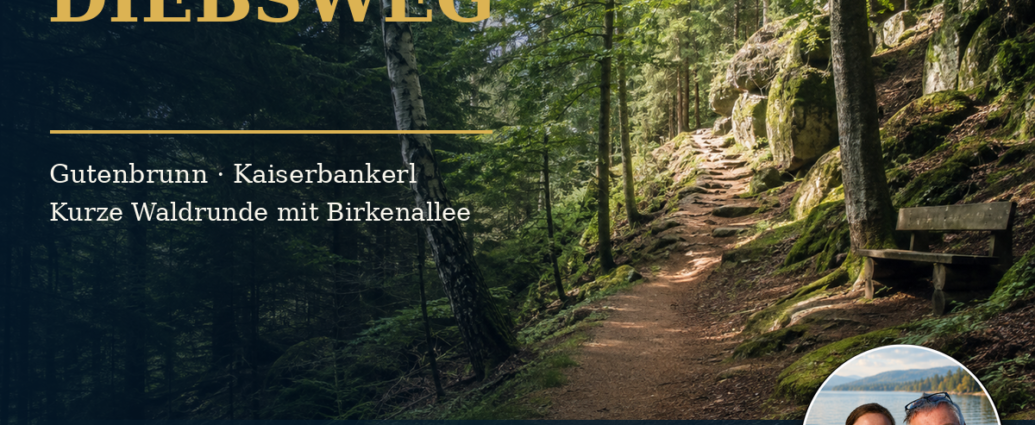
Short loop hike to the Kaiserbankerl on Diebsweg Gutenbrunn.
The Diebsweg at Gutenbrunn No. 43 is a short, varied loop hike that starts right at the church square.
It connects the historic town center with a short, steep climb over a distance of less than four kilometers.
These include quiet forest trails, the birch-lined avenue, and the trail leading to the Kaiserbankerl.
This tour is especially suitable for guests who want to experience the Weinsberg Forest without spending the whole day hiking.
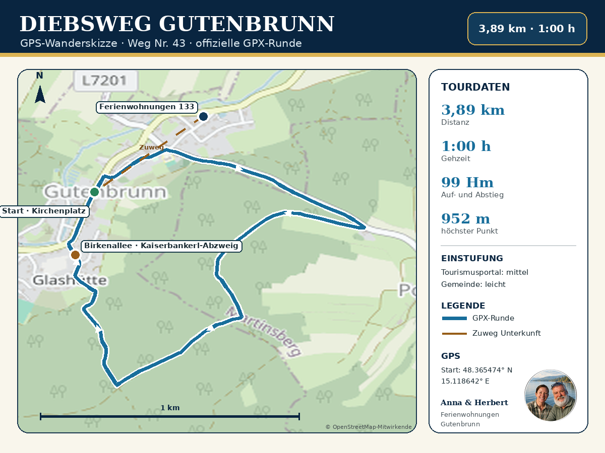
The current official route description from Waldviertel Tourism lists 3.89 kilometers. The hike takes about one hour and involves 99 meters of elevation gain and loss. For the Diebsweg Gutenbrunn, the slightly different older specifications of four kilometers, one and a half hours, and 106 meters of elevation gain still apply.
Depending on your pace and breaks, you should plan on about an hour and a half. Additionally, the time frame may be extended due to breaks. Information on physical fitness helps ensure you can complete the route safely. Weather conditions also affect the plan. Accurate on-site orientation helps ensure a safe journey.
For guests staying at the Gutenbrunn vacation apartments, the Diebsweg Gutenbrunn trail is particularly convenient. The official starting point at Kirchenplatz is just a short walk from Gutenbrunn 133. So you can leave your car behind. You can set out on the hike on a whim—in the morning, in the afternoon, or for a leisurely evening stroll.
The Gutenbrunn Thieves' Trail at a Glance
- Trail Number: 43
- Start and finish: Gutenbrunn Church Square
- Route description: A short loop hike with sections through the forest and through town
- Distance according to the current tourism portal: 3.89 kilometers
- Calculated length of the current GPX file: approximately 3.89 kilometers
- Walking time according to the current tourism website: about 1 hour without long breaks
- Estimated time for a leisurely walk: about 1 to 1.5 hours
- Ascent: 99 meters in elevation
- Descent: 99 meters in elevation
- Lowest point: 853 meters
- Highest point: 952 meters
- Fitness level according to the tourism portal: 2 out of 6
- Experience and Scenery Ratings: 5 out of 6 each
- Features: Loop trail and family-friendly
- Road surface, according to the municipality: approximately 37 percent asphalt and 63 percent gravel and forest roads
- Points of interest: birch-lined avenue, forest trail, stone fountain, and turnoff to the Kaiserbankerl
- Signage: Hiking Trail No. 43
- Recommended gear: sturdy shoes, weather-appropriate clothing, water, and a fully charged cell phone
The current tour description from Waldviertel Tourismus was updated on August 3, 2026. The GPX file provided there, containing 180 waypoints, forms the basis of our hiking map.
Why the Diebsweg is a Great Fit for a Day of Vacation
Not every hike has to be long or strenuous. Especially on the day you arrive or depart, after a road trip, or before a relaxing evening, a short walk is often ideal. The Diebsweg offers a surprising amount of variety in a manageable amount of time: local history, elevation gain, a forest atmosphere, and small rest areas are all close together.
If you walk at a brisk pace, you can complete the current GPX route in about the official time. If you’d like to take a break at the Kaiserbankerl, take photos, or simply enjoy the forest, you should plan on about an hour and a half. That way, the tour remains relaxed and doesn’t turn into a race against the clock.
Start at Kirchenplatz in Gutenbrunn
The start and finish are located at Kirchenplatz. Here you'll find the Pilgrimage Church of the Visitation of Mary, the Gutenbrunn Castle and other buildings in the historic town center, all located close together. Even before reaching the first section of the forest, the loop therefore gives a good impression of the town.
The current directions from Waldviertel Tourismus start at the church square, pass by the castle, and head toward the intersection leading to Edlesberg. The route then branches off to the right and climbs gently past the school and cemetery toward the edge of the forest.
The trail marker numbered 43 remains the most important guide along the way. A GPX file or our hiking map is a useful supplement, but it does not replace the local signage or the need to follow current directions.
From the outskirts of town into the Weinsberg Forest
Past the school and the cemetery, the surroundings become quieter. A forest path runs parallel to the road for about one kilometer and leads to a solitary farmstead. The route thus shifts from the built-up areas of Gutenbrunn to the landscape typical of the Weinsberg Forest, consisting of forest trails, mixed woodland, spruce stands, and moss-covered granite boulders.
The trail is short, but not entirely flat. The total elevation gain is about 99 meters. The steeper section mentioned by the municipality—which is about 200 meters long—can really get your heart rate up. If you walk slowly and stop briefly when needed, you can easily break the climb down into smaller sections.
After rain, forest and gravel trails can be damp, soft, or slippery. That’s why shoes with grippy soles are a good idea, even on this short hike.
Intersection of Diebsweg and a quiet stretch of forest
From the isolated farmstead, the current route leads along a beautiful forest path to the Diebsweg intersection. This is where the return trip begins, heading toward Birkenallee and the town center. The dense forest creates a peaceful atmosphere and offers pleasant shade on warm days.
The name „Diebsweg“ piques curiosity, but the official trail descriptions currently do not explain its historical origin. Therefore, the name should not be embellished with a made-up story. The trail’s special appeal lies specifically in its short length, the quiet stretch of forest, and its proximity to the town.
Please stay on the marked trails, respect forestry operations, and take your trash with you. During a storm or immediately afterward, you should avoid the forest due to the risk of falling branches.
Birch Avenue, Steinbrunnen, and Kaiserbankerl
On the way back, you’ll reach the Birkenallee area. The market town also describes the turnoff to the Kaiserbankerl here. The Kaiserbankerl is a charming spot for a short break and provides a specific stop along this short hike.
Since the detour to the Kaiserbankerl is not listed as a separate GPS waypoint in the current tourist guide, you should pay close attention to the trail markers once you’re there. That’s why our hiking map marks the area of the birch-lined avenue and the turnoff, rather than inventing a position for the bench that’s supposedly accurate to the meter.
The trail continues past the stone fountain through Gutenbrunn and back to the church square. The tour thus ends once again in the center of town, where, depending on opening hours, you can stop for a bite to eat or take another short walk.
Two official descriptions—two directions of travel
Current official sources describe the loop trail in different directions. Waldviertel Tourismus describes the route as starting at the church square, passing the castle, the school, and the cemetery, and then continuing past the isolated farmstead to the Diebsweg intersection. The municipality first describes the steeper ascent to Birkenallee and the turnoff to Kaiserbankerl.
Both descriptions refer to the same loop trail. It is important for visitors to follow trail marker No. 43. Our GPS hiking map is based on the route of the GPX file currently available for download: from the church square past the castle, school, and cemetery to the eastern and southern parts of the loop, and then back via Birkenallee.
If you prefer to walk the steeper section uphill rather than downhill, you can start the loop in the opposite direction. In that case, you should pay close attention to the signage, since the GPX navigation will then proceed in the opposite direction of the one stored in the device.
Easy or medium? Explanation of the difficulty levels
Official information also varies when it comes to the Diebsweg. The market town of Gutenbrunn describes the trail as easy. The tourism portal, updated on August 3, 2026, however, rates it as moderate, though it assigns it a fitness level of 2 on a six-point scale and lists it as family-friendly.
The different difficulty ratings can be understood as follows: The loop is short and has an elevation gain of only about 100 meters. However, there is a steeper section as well as gravel and forest trails. When the ground is dry, the hike is easily manageable for many experienced hikers. Wet conditions, snow, ice, or limited surefootedness can significantly change the nature of the hike.
A single difficulty rating is therefore no substitute for your own judgment. If you’re unsure, you should start slowly and, if necessary, turn back before the steeper section becomes difficult.
Is the Diebsweg suitable for older guests?
For active, steady-footed older guests, the Diebsweg can be a very suitable hike. The route is less than four kilometers long, starts right in town, and can be walked at a leisurely pace with breaks. However, the short, steeper climb should not be underestimated.
Hiking poles can provide additional safety on uphill or damp forest trails. Guests with balance issues, cardiovascular conditions, or significant limitations in their ability to walk should realistically assess their own physical capabilities and, if necessary, choose an even flatter local loop.
Anna and Herbert are happy to help their guests plan a tour that’s appropriate for the weather, trail conditions, and their personal fitness level.
Is Diebsweg accessible for strollers or wheelchairs?
The municipality and the tourism portal describe the route as family-friendly. However, there is no explicit designation for the Diebsweg as being suitable for strollers, wheelchairs, or walkers.
Since about 63 percent of the route runs along gravel and forest trails and includes a short, steeper section, the loop should not be considered barrier-free should be taken into account. With an all-terrain stroller, it may work well in sections where the ground is dry; the model, tires, and current trail conditions are key factors.
For wheelchairs, walkers, or people with more severe mobility impairments, we recommend having the sections individually inspected on-site. It is not possible to make a definitive statement without a current on-site inspection.
Diebsweg in Winter
Waldviertel Tourism also offers its own winter version of the route. It is listed as 3.91 kilometers long, taking about 1 hour and 25 minutes to complete, with an elevation gain of 107 meters. The route starts at the mountain bike information board in the town center.
In winter, snow, ice, and shorter days significantly change the conditions. The summer GPX file should not be relied upon without verification as a guarantee that the trail has been cleared. Winter-appropriate footwear, warm clothing, and an early return are essential. Current local advisories always take precedence.
The best time of year for the tour
The tour is officially recommended year-round. Dry days in spring, summer, and fall are especially pleasant. In spring, the birch-lined avenue looks bright and fresh; in summer, the forest offers shade; and in fall, moss, fallen leaves, and warm light make for a particularly atmospheric walk.
After prolonged rain, the unpaved sections may be slippery. In the event of thunderstorms, strong winds, heavy snowfall, or ongoing forestry work, the hike should be postponed or adjusted to suit local conditions.
What should you bring?
For the Diebsweg, we recommend:
- sturdy shoes with non-slip soles
- enough water
- A small snack for a break on the bench
- Sun and Rain Protection
- a charged cell phone
- GPX file or hiking map
- hiking poles, if needed
- small first-aid kit and blister bandages
- Summer Insect Screens
- a bag for your own trash
Even on a short trip, it’s worth checking the weather and daylight hours. The hours of operation for places to stop for a bite to eat may vary by season.
GPS Data and Navigation
- Start and finish at Kirchenplatz: 48.365474° N, 15.118642° E
- Gutenbrunn 133 Vacation Rentals: 48.368830° N, 15.124330° E
- Birkenallee area and Kaiserbankerl junction: shown on the map as a general location, not as an exact GPS coordinate
The hiking map shows the entire route of the current official GPX file. The short approach from the vacation apartments to the church square is shown schematically and clearly separated from the actual loop trail.
Round off your walk through town
After returning to the church square, the hike can be nicely rounded off with a visit to the pilgrimage church, the Gutenbrunner Spring, the Inhalatorium, or the Truckerhaus. Which facilities are accessible or open depends on the season, the day of the week, and the event calendar.
If you’d rather relax right after your hike, the Gutenbrunn vacation apartments are just a few minutes away. This makes the Diebsweg a hassle-free nature experience that fits seamlessly into your vacation.
Our Conclusion on the Diebsweg in Gutenbrunn
Diebsweg No. 43 is a short but by no means monotonous loop hike. The historic town center, forest trails, a short steeper section, a birch-lined avenue, a stone fountain, and the Kaiserbankerl offer plenty of variety over less than four kilometers.
This tour is especially well-suited for guests who want to explore Gutenbrunn on foot and spend about an hour and a half in nature. With sturdy shoes, a leisurely pace, and a break on a bench, it makes for a compact Waldviertel hike right on our doorstep.
Book a vacation rental in Gutenbrunn directly
Would you like to explore the Diebsweg and other hiking trails around Gutenbrunn? Our vacation rentals offer peace and quiet, plenty of space, and personalized service from Anna and Herbert.
You can inquire about or book your vacation rental right here:
Comments are closed, but trackbacks and pingbacks are open.