


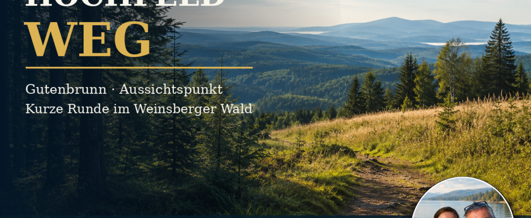
In addition, a short loop hike leads to the lookout point on Hochfeldweg Gutenbrunn.
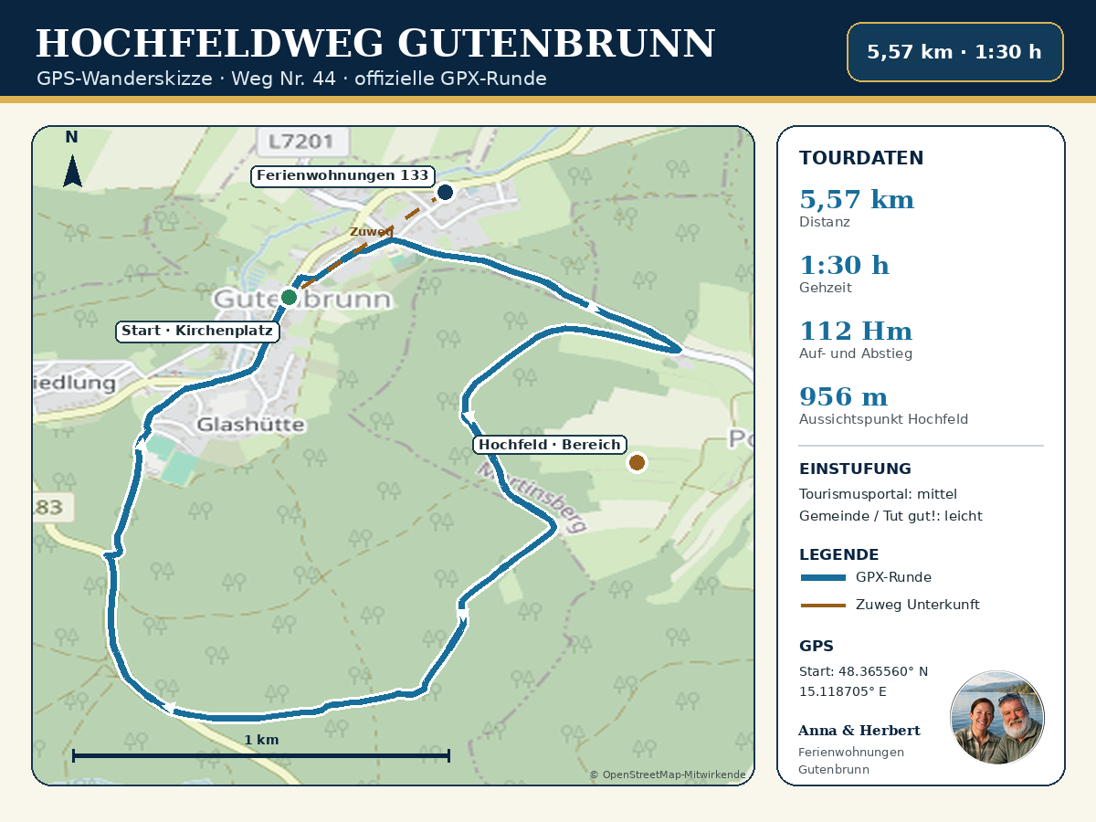
The Hochfeldweg in Gutenbrunn, No. 44, is a short loop hike for anyone who wants to combine a walk in the woods, scenic views, and exercise without having to set aside an entire day for hiking. The hike begins in the center of town at Kirchenplatz, passes by the castle, climbs up to the Hochfeld via the outskirts of town, and returns to Gutenbrunn through the Weinsberger Forest.
With an official length of 5.57 kilometers and a walking time of about an hour and a half, the Hochfeldweg is one of the shorter marked loop trails around Gutenbrunn. The viewpoint at Hochfeld, at 956 meters above sea level, is the scenic highlight of the trail. At the same time, forest trails, open stretches, and the view back toward the village provide plenty of variety.
This tour is especially convenient for guests staying at the Gutenbrunn vacation apartments: The official starting point at Kirchenplatz is just a short walk from our accommodations at Gutenbrunn 133. So you can leave your car behind, and the hike begins practically right outside the front door.
The Gutenbrunn High-Field Trail at a Glance
- Trail Number: 44
- Start and finish: Gutenbrunn Church Square
- Type: Short, scenic loop hike
- Distance according to the current tourism portal: 5.57 kilometers
- Calculated length of the current GPX file: approximately 5.56 kilometers
- Walking time: about 1 hour and 30 minutes, excluding longer breaks
- Ascent: 112 meters in elevation
- Descent: 112 meters in elevation
- Lowest point: 853 meters
- Highest point: 965 meters
- Hochfeld Lookout Point: 956 meters above sea level
- Fitness level according to the tourism portal: 2 out of 6
- Experience and Scenery Ratings: 5 out of 6 each
- Features: Loop trail and family-friendly
- Road surface, according to the municipality: approximately 42 percent asphalt and 58 percent gravel and forest roads
- Signage: Hiking Trail No. 44
- Recommended gear: sturdy shoes, weather-appropriate clothing, water, and a fully charged cell phone
The current tour description from Waldviertel Tourismus was updated on August 3, 2026. The GPX file provided with it serves as the basis for our hiking map.
Why the Hochfeldweg is a great choice for a half-day getaway
Besides, not every day of your vacation has to be filled with a long or strenuous hike. The Gutenbrunn Hochfeldweg trail is perfect for a morning or afternoon walk and can be combined with other destinations in town. After the walk, there’s plenty of time for a break, a visit to the inhalatorium, or a relaxing end to the day at your vacation rental.
The trail is long enough to fully enjoy the exercise and nature, but short enough to walk at a leisurely pace. If you plan to take photos at the lookout point, take breaks along the way, or look closely for natural scenes in the forest, you should allow about two hours.
Start at Kirchenplatz in Gutenbrunn
The official starting and finishing point is at Kirchenplatz. Here, the Pilgrimage Church of the Visitation of Mary, the historic castle, and other buildings significant to Gutenbrunn’s local history are all located close together. Right from the start of the tour, you’ll experience a blend of culture and scenery.
From Kirchenplatz, the path leads past the castle toward the intersection leading to Edlesberg. The route then branches off to the right and climbs gently out of the town. You pass the area near the school and the cemetery and finally reach the edge of the forest.
Sign No. 44 is essential for finding your way. The GPX file and our hiking map are useful supplements, but they are no substitute for the local trail signs while you're out on the trail.
A gentle climb from the village to the edge of the forest
The first climb is manageable and spreads out over a longer stretch. This allows you to gradually gain elevation without having to tackle a particularly steep mountain trail right at the start. From the upper edge of town, the view changes: houses and the church tower fade into the background, while meadows and woods come more into focus.
This section takes on a very different appearance depending on the season. In the spring, the meadows and forest edges look fresh and bright. In the summer, the trees provide shade. In the fall, the warm light and the colors of the forest create a particularly peaceful atmosphere.
After rain, unpaved sections may be wet or slippery. Therefore, shoes with good traction are recommended even on this relatively short loop.
On the forest trail toward Hochfeld
At the edge of the forest, follow a path that runs parallel to the road for about one kilometer. This section leads to a solitary farmstead. From there, turn right and continue up a moderate incline toward Hochfeld.
The alternation between open and forested areas makes this part of the hike interesting. Time and again, the view opens up through gaps in the trees to reveal the surrounding landscape. At the same time, the trail is easy to follow and, according to the current tourism portal, requires only a low level of fitness—a rating of 2 on a six-point scale.
Nevertheless, altitude, weather, and your personal walking pace should not be underestimated. Gutenbrunn is already at an elevation of about 858 meters above sea level, and the Hochfeld is significantly higher. Wind and temperature may therefore feel different than at lower elevations.
Viewpoint at Hochfeld, 956 meters above sea level
The Hochfeld lookout point is the main destination of the loop. At 956 meters above sea level, the landscape opens up, and the view stretches across the forested surroundings of the southern Waldviertel. Depending on the weather and visibility, the nearby forests stand out clearly or fade into the distance as soft blue layers.
It’s worth setting aside a few extra minutes for a break. The area looks its best when you don’t just stop briefly, but consciously let your gaze wander over the landscape. Binoculars or a camera can be useful companions here.
The official tour lists the highest point along the entire route as 965 meters. The designated lookout point at Hochfeld is listed as 956 meters. These two figures are not contradictory: the highest point along the trail does not have to be exactly the same as the lookout point.
Back through the Weinsberg Forest
After Hochfeld, the route leads through a dense forest. Waldviertel Tourism specifically recommends this section as a highlight for the Mushroom Hunting However, anyone who picks mushrooms should only take species that can be reliably identified and should follow the applicable rules and limit their harvest to personal use.
Even if you’re not planning to collect anything, it’s worth taking a leisurely look at the forest floor. Mosses, ferns, granite boulders, pinecones, and shifting light make the walk back an enjoyable experience. Please stay on the designated trails and take your trash with you.
Eventually, you’ll reach the country road. After about 500 meters, turn right toward Gutenbrunn. The path passes by the public works yard and the spot known as „Glashütte“ before returning to the starting point at Kirchenplatz.
Easy or medium? Explanation of the official ratings
There are currently differing official descriptions of the difficulty level. The market town of Gutenbrunn describes the Hochfeldweg as “easy.“ “Auch tut gut!” lists it as 5.5 kilometers long, with 114 meters of elevation gain, and a difficulty level of “easy.”.
The Waldviertel Tourismus tourism portal, updated on August 3, 2026, rates the loop as “moderate,” however. At the same time, it lists a low fitness level requirement of 2 out of 6 and describes the trail as family-friendly. The distance, walking time, and elevation gain are nearly identical across the platforms.
In practical terms, this means that the Hochfeldweg is a short hike with moderate elevation changes, but it includes sections through the woods, on gravel, and uphill. Anyone who feels unsteady on uneven terrain or plans to hike after it has rained should approach this route with caution. Your personal surefootedness and the current trail conditions are more important than a single difficulty rating.
Is the Hochfeldweg suitable for older guests?
For active, sure-footed older guests, the Hochfeldweg is often a pleasant choice. The route is less than six kilometers long, and the official 112 meters of elevation gain are spread out over the loop. If you walk slowly and take a break at the lookout point, you can enjoy the hike without feeling rushed.
Sturdy shoes are still important. Hiking poles can provide additional safety on wet ground or on sloping forest trails. Guests with cardiovascular conditions, balance issues, or limited mobility should realistically assess their own physical capabilities and, if in doubt, choose a shorter alternative.
Anna and Herbert are happy to help their guests choose a hike that suits their fitness level and the current weather conditions.
Is the Hochfeldweg suitable for strollers?
The market town describes the Hochfeldweg as stroller-friendly and family-friendly. The current tourism portal confirms its family-friendliness but does not explicitly list stroller-friendliness as one of its features.
Since about 58 percent of the route runs along gravel and forest trails, the actual passability depends heavily on the stroller, the weather, and the trail conditions. An all-terrain model is more suitable than a stroller with small wheels. After rain or forestry work, certain sections may be significantly more difficult to navigate.
As fully accessible or wheelchair accessible that round should not be taken into account.
The best time of year for the Hochfeldweg trail
The trail is officially recommended for hiking year-round. Dry days from spring through fall are particularly pleasant. In summer, the wooded sections provide shade, while in fall, the trail offers scenic views, mushroom hunting, and colorful forest edges.
The hike can also be enjoyable in winter, but snow, ice, and shorter days change the challenges. In that case, winter-appropriate footwear, warm clothing, and planning your hike well in advance are essential. In the event of storms, thunderstorms, heavy rain, or forestry work, you should postpone the hike or adjust your plans based on local advisories.
What should you bring?
For the Hochfeldweg, we recommend:
- sturdy shoes with non-slip soles
- enough water
- a small snack or a granola bar
- Sun and Rain Protection
- a charged cell phone
- GPX file or hiking map
- hiking poles, if needed
- small first-aid kit and blister bandages
- Summer Insect Screens
- a bag for your own trash
Even for a short trip, you should check the weather before setting out. The hours of operation for places to stop for refreshments may vary by season.
GPS Data and Navigation
- Start and finish at Kirchenplatz: 48.365560° N, 15.118705° E
- Gutenbrunn 133 Vacation Rentals: 48.368830° N, 15.124330° E
- Hochfeld, listed as a field name in OpenStreetMap: 48.360393° N, 15.131228° E
The hiking map provided shows the complete route of the current official GPX file. The short approach from the vacation apartments to the church square is shown schematically for orientation purposes and is clearly separated from the actual loop trail.
Wrap up the hiking day in Gutenbrunn
After returning to the church square, the outing can be combined with other destinations in town. The Inhalation Room, which Gutenbrunner Spring, the pilgrimage church, and the Trucker House are located close to one another. Which facilities are open depends on the season, the day of the week, and the event calendar.
If you’d rather relax after the hike, you can be back at the Gutenbrunn vacation apartments in just a few minutes. There, you can reflect on your hike while enjoying a snack or a cozy evening.
Our Conclusion on the Gutenbrunn Hochfeldweg Trail
The Hochfeldweg No. 44 is a short, varied loop hike that starts right in Gutenbrunn. Its appeal lies in the combination of the historic town center, a gentle climb, a scenic overlook, and a peaceful forest trail.
This tour is especially well-suited for guests who want to spend about two hours in nature while still having plenty of time for other vacation activities. If you wear sturdy shoes, set your own pace, and take a break at Hochfeld, you’ll enjoy a compact and scenic loop through Gutenbrunn.
Book a vacation rental in Gutenbrunn directly
Would you like to explore the Hochfeldweg and other hiking trails around Gutenbrunn? Our vacation rentals offer peace and quiet, plenty of space, and personalized service from Anna and Herbert.
You can inquire about or book your vacation rental right here:
Comments are closed, but trackbacks and pingbacks are open.