


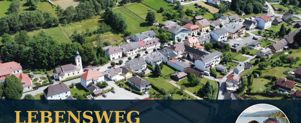
Long-distance hiking in the southern Waldviertel is part of the Lebensweg Gutenbrunn.
Gutenbrunn isn't just a good starting point for short walks and loop hikes.
The town is also located along one of Lower Austria’s most extraordinary long-distance hiking trails: the Lebensweg Gutenbrunn in the southern Waldviertel.
Stretching about 260 kilometers, this trail combines nature, physical activity, and the major stages of human life.
The Gutenbrunn Trail consists of 13 themed stages and is typically completed in about 14 days of hiking.
As it does so, it forms a large figure-eight loop—a symbol reminiscent of infinity.
Each stage is dedicated to a different phase of life—from origins and birth, through childhood, adolescence, and adulthood, to old age, saying goodbye, and one’s own roots.
Gutenbrunn plays a special role in this. The town is the destination of the fourth stage, „Ages 6–14: Learning,“ and the starting point of the fifth stage, “Puberty to Age 20: The Wild Years.” For guests staying at the Gutenbrunn vacation apartments, the trailhead is practically right on their doorstep.
This article provides a brief overview of the entire route and then focuses on the two sections in Gutenbrunn. We describe Section 5—from Gutenbrunn past the Edlesbergerteich—in particular detail, and Martinsberg to Kirchschlag. An up-to-date GPS map and the official GPX file from Waldviertel Tourism are available for this route.
A Glance at the Journey of Life
- Total length: about 260 kilometers
- Number: 13 stages of life
- Typical total duration: about 14 days of hiking
- Trail Type: Circular and long-distance hiking trail in the shape of a figure-eight loop
- Region: Southern Waldviertel
- Features: Forests, ponds, stream valleys, plateaus, villages, and cultural landscape
- Difficulty: easy to moderate, depending on the stage; basic fitness required
- Starting Point: Generally possible at various locations and also in stages
- Gutenbrunn: Finish of Stage 4 and Start of Stage 5
- Navigation: Use on-site markers as well as a current hiking map or GPX file
- Key Planning Considerations: Organize lodging, meals, and return transportation in advance
Life’s journey is not an alpine high-mountain hike. Still, it’s no walk in the park. Daily distances of about 20 kilometers, long stretches through the forest, and changeable weather require physical fitness, appropriate footwear, and realistic time management.
What Makes a Life Journey Special
The trail connects the Ysper-Weitental Circular Hiking Trail and the Kremstal Trail to form a large figure-eight loop. However, what makes it special is not just its route. The individual daily sections correspond to stages of life and invite hikers to reflect on their own stories as they walk.
It doesn't have to be solemn or difficult. Some hikers consciously reflect on the topic at hand. Others simply enjoy the forests, the water, and the sweeping views. Both approaches fit into life's journey. It provides a framework for reflection without dictating how someone should feel.
There are so-called “heart points” along the route. These are places, landmarks, or specially designed stops that offer a particularly memorable experience. In Gutenbrunn, these include, among others, the “Figure of Life” and the Inhalation Room. The Hansl pond is listed as the focal point of the fourth stage.
Gutenbrunn: A Bridge Between Two Stages of Life
Gutenbrunn marks the transition from childhood to adolescence. The fourth stage focuses on learning, the early school years, and the gradual understanding of time and the future. The fifth stage addresses puberty, self-discovery, first love, insecurity, and growing up.
This change fits surprisingly well with the landscape. The fourth stage leads through long stretches of forest and over the Weinsberg to Gutenbrunn. The fifth stage leaves the village and heads toward Edlesbergerteich, Martinsberg, and Kirchschlag. Forests, open countryside, and villages alternate—much like the familiar and the new in one’s youth.
Guests don't have to walk the entire 260-kilometer route to experience this concept. You can hike Stage 5 as a day trip, explore just the section around Gutenbrunn, or combine several stages of the Lebensweg with scheduled transfers.
Stage 4: From Dorfstetten to Gutenbrunn
The fourth stage of the Life Path is titled „Ages 6–14: Learning.“ It leads from Dorfstetten past Pfaffenstegteich, Bärnkopf and from Weinsberg to Gutenbrunn.
Official Tour Dates for Stage 4
- Distance: 24.35 kilometers
- Walking time: about 6 hours and 40 minutes
- Ascent: 449 meters in elevation
- Descent: 321 meters in elevation
- Lowest point: 705 meters
- Highest point: 1,021 meters
- Difficulty: medium
- Start: Dorfstetten
- Destination: Gutenbrunn
This stage is heavily forested and physically demanding. After Dorfstetten, it runs along the Kleine Ysper and past the Schlesinger pond ... The route climbs toward the Weinsberg via Bärnkopf. It then follows the Große Ysper toward Ysperklamm and finally leads to Gutenbrunn.
If you want to hike this stage, you’ll need to start early due to the distance and arrange a ride to Dorfstetten in advance. It’s not a loop and ends in Gutenbrunn. This route is especially convenient for guests who want to return to their vacation rental after a long day of hiking.
At the end of the stage, a quiet visit to the inhalatorium is a good idea. The facility is located directly on the Lebensweg. According to the municipality, it is open seasonally from May through October. We see it primarily as a place to sit, relax, and breathe mindfully—not as a substitute for medical advice or treatment.
Stage 5: From Gutenbrunn to Kirchschlag
The fifth stage begins in Gutenbrunn and is themed “Puberty through Age 20: The Wild Years.” It leads past the Edlesbergerteich and Martinsberg to Kirchschlag.
Official Tour Dates for Stage 5
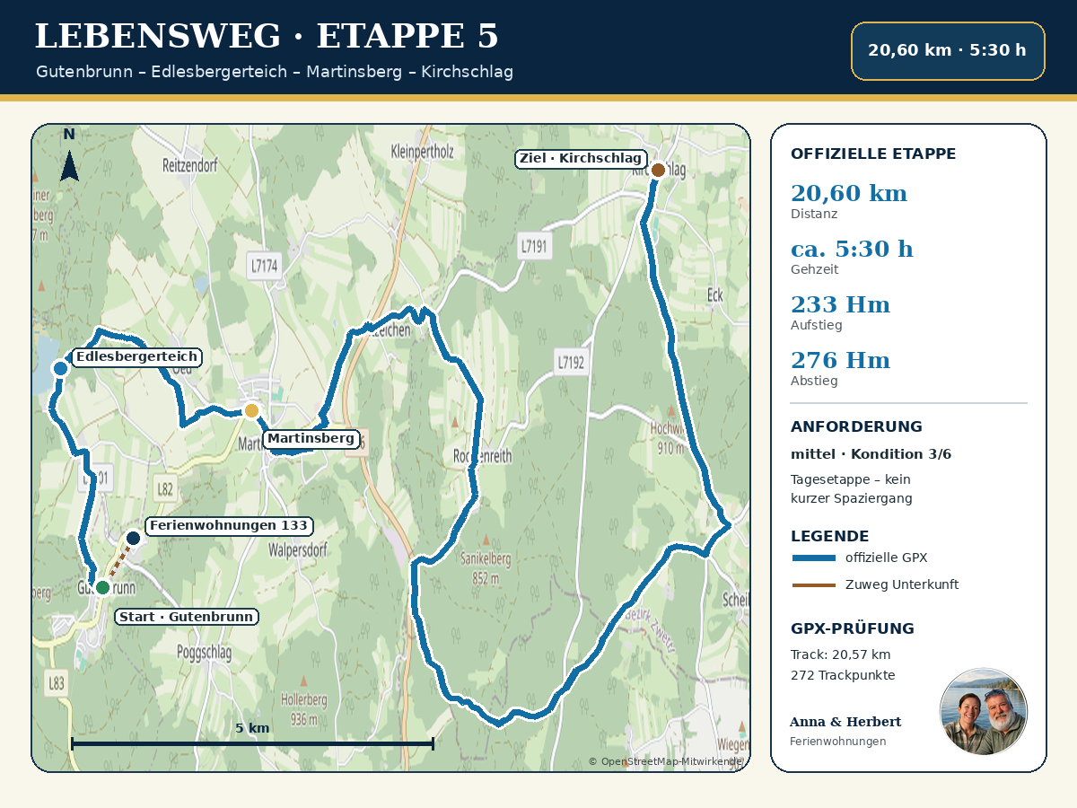
- Distance: 20.60 kilometers
- Walking time: about 5 hours and 30 minutes
- Ascent: 233 meters in elevation
- Descent: 276 meters in elevation
- Lowest point: 747 meters
- Highest point: 897 meters
- Difficulty: medium
- Fitness level: 3 out of 6
- Start: Gutenbrunn
- Destination: Kirchschlag
The official GPX track we reviewed contains 272 track points and measures approximately 20.57 kilometers. The slight discrepancy from the published distance of 20.60 kilometers is due to rounding and the technical calculations between the GPS points.
The Start in Gutenbrunn
The official trail begins in the center of Gutenbrunn, near the church, the spring, and the “Statue of Life.” From the Gutenbrunn vacation rentals, the trailhead is accessible via a short access path. This access path is marked with a dashed line on our map and is not included in the official 20.60 kilometers.
Before setting out, it’s worth taking a quick look at the „Life Journey“ sculpture next to the church. It symbolizes the transition between life’s stages. If you’d like, you can reflect on today’s theme here: What did your own “wild years” mean to you? What decisions, encounters, or uncertainties have stayed with you?
After that, it’s time to get back to the practical details: Has the GPX file been loaded? Has transportation back from Kirchschlag been arranged? Do I have water, a snack, and rain gear in my backpack? Only then does the day’s hike begin.
From Gutenbrunn to Edlesbergerteich
The first section leads out of Gutenbrunn toward Edlesberg. Forest trails and quiet paths lead hikers to the Edlesbergerteich, which is also Lake Edlesberg is called.
The pond is one of the most scenic stops on this leg of the route. It lies at an elevation of about 876 meters above sea level and was created in the 18th century as a log-floating pond. The water was originally used for the timber industry. Today, the area is characterized by tranquility, the forest, and the expansive body of water.
On warm days, the Edlesbergerteich is used as a swimming lake. However, if you’re planning a long day hike, you should only schedule a swim break if the weather, water conditions, available time, and your personal fitness level are all right. After your swim, you’ll still have many kilometers to go before reaching Kirchschlag.
Our Tip for Your Break
The lake is a good spot for a short break early on. Have a drink, check your pace, and see if you need to adjust your clothing or backpack. A break of ten to fifteen minutes is usually enough to keep your hiking rhythm going.
Via the Observatory to Martinsberg
From Edlesbergerteich, the trail continues toward Martinsberg. The official trail guide lists the observatory as a landmark. In this section, the landscape alternates more frequently between forest, open areas, and built-up areas.
Martinsberg is a good option for a longer stopover. Depending on the actual hours of operation, you can stock up on food or drinks here. However, you shouldn’t count on this: closing days, holiday periods, and last-minute changes are possible in rural areas. The Lebensweg Association therefore strongly recommends bringing an emergency ration and plenty of drinks with you.
Once you reach Martinsberg, you’ll have covered roughly the first half of the stage. You should still have enough energy left for the forest trails and connecting paths that lie ahead.
About Quotation Marks and Roggenreith
After Martinsberg, the route follows the Kremstalweg via Zitatzeichen to Roggenreith. This section showcases the tranquil side of the southern Waldviertel: small villages, farmland, and long stretches without any tourist infrastructure.
That is precisely what makes long-distance hiking so appealing. The trail isn’t defined by any single point of interest. It thrives on the steady rhythm of walking, the changing scenery, and the experience of covering a long distance under one’s own power.
To help with navigation, you should check the GPX file regularly, but not constantly. It’s especially worth taking a quick look at junctions. If the trail markings change or a sign is obscured, the saved route will help you react in time.
Through the Hundsbach Forest to the Kleine Krems
After the Hundsbachwald, the route crosses the Ysper-Weitentalweg once more and then continues along the Kremstalweg. The Kleine Krems has its source in Primassen. From there, the Lebensweg leads through Hochwald toward Kirchschlag.
This final stretch may feel longer than the remaining kilometers would suggest. After several hours, your concentration and surefootedness will begin to wane. Therefore, be sure to plan a short break to hydrate in the afternoon and save some energy for the final stretch.
At dusk, during thunderstorms, storms, or when you are extremely exhausted, you should not prioritize an ambitious goal over safety. Because, according to the Lebensweg FAQ, cell phone reception is not available everywhere, you should inform someone you trust of your route and planned arrival time.
Destination in Kirchschlag
The stage ends in Kirchschlag. Since this is a one-way hike, there is no short loop trail back to Gutenbrunn. Transportation back must therefore be arranged in advance.
The Lebensweg Association recommends booking taxis a few days in advance or at least checking for availability. Accommodation and dining establishments should also be contacted well in advance. In rural areas, you cannot count on finding a transfer at the last minute.
For guests staying in our vacation apartments, it’s especially important to have a clear agreement: Where exactly is the meeting point in Kirchschlag? What time was agreed upon? Is there a phone number to call in case of delays? These small details help prevent unnecessary stress after a long day of hiking.
Three Options for Guests at the Gutenbrunn Vacation Rentals
Option 1: The entire Stage 5
You'll start in Gutenbrunn in the morning and hike the official 20.60 kilometers to Kirchschlag. For this, you'll need to be in good physical shape, have the proper hiking gear, and arrange for transportation back.
Option 2: Explore only the Gutenbrunn trailhead
If you don’t want to hike a long day’s stage, visit the “Figure of Life,” the historic town center, and the Inhalatorium. This way, you can experience the concept of the “Path of Life” without having to hike 20 kilometers. We also offer our own historic walking tour of the town center.
Option 3: Hike Stage 4 to Gutenbrunn
With a morning transfer to Dorfstetten, guests in good physical condition can walk the 24.35-kilometer fourth stage and arrive directly in Gutenbrunn. This route is longer and has more elevation gain than Stage 5.
Gear for Stage 5
For a safe and enjoyable hike, we recommend:
- broken-in hiking or trekking shoes with grippy soles
- Daypack with Rain Cover
- enough water
- Snacks and additional emergency rations
- Rain jacket and an extra layer for warmth
- Sun and Tick Protection
- Cell phone with a fully charged battery
- GPX file or hiking map saved offline
- small power bank
- personal first-aid kit and blister bandages
- personal medications
- Phone number for the arranged return transportation
You shouldn't break in new shoes on a stage that's more than 20 kilometers long. If you're prone to blisters, bring a second pair of hiking socks.
Best Time for Hiking
Life’s journey can generally be experienced as different seasons. For Stage 5, late spring, summer, and early fall are particularly fitting. However, the current trail, weather, and daylight conditions are the deciding factors.
In the summer, you should set out early and bring plenty of water. It can get hot on open stretches. After long periods of rain, forest trails may be muddy. In the fall, it gets dark earlier. In the winter, snow, ice, and uncleared sections may require different gear and significantly more time.
Check the weather forecast the night before and in the morning. If there is a storm warning, a risk of thunderstorms, or extreme heat, you should postpone or shorten your hike.
Assess Your Fitness Level Realistically
The official rating is „moderate,“ and the fitness level required is 3 out of 6. These ratings are helpful, but they are no substitute for your own personal assessment.
If you regularly hike ten to fifteen kilometers and still feel good afterward, you can gradually work your way up to a day-long hike like this. If you rarely hike longer distances, it’s better to start with a shorter loop hike in Gutenbrunn.
The estimated walking time of 5 hours and 30 minutes is a rough guide that does not include extended breaks. With photo stops, a rest at Edlesbergerteich, and a visit to Martinsberg, the total duration of the day may be seven hours or more.
Is this stage suitable for seniors?
Age alone is not the deciding factor. Well-trained older hikers can complete the route, while untrained younger people may have difficulty doing so. The key factors are stamina, sure-footedness, joint flexibility, and experience with long day hikes.
If you're unsure, start by choosing a shorter route around Gutenbrunn. The full stage is not barrier-free and is not suitable for wheelchairs, walkers, or standard strollers.
Hiking with Your Dog
Dogs You’ll also need to be in good enough shape to walk more than 20 kilometers. Be sure to plan for water, breaks, and the weather. In the forest and in agricultural areas, the dog should be kept on a leash at all times. It goes without saying that you should be considerate of wildlife, grazing animals, other hikers, and local leash laws.
Before booking your return trip, you must confirm whether you can bring a dog with you.
Navigation and GPX File
The GPX file provided is the current official file from Waldviertel Tourism for Stage 5. It runs from Gutenbrunn via Edlesbergerteich and Martinsberg to Kirchschlag.
A GPX file is no substitute for paying attention. Road closures, forestry work, detours, or damage can change at short notice. Therefore, always pay attention to the actual situation, road closures, and signs on site.
Save the file offline before your trip. Cell phone reception may be limited in some parts of the region. A printed map or a second navigation device will help ensure your safety.
Why Gutenbrunn Is a Good Base for Your Life's Journey
Gutenbrunn is located exactly between two key stages. Hikers can arrive here, set out from here, or take a rest day. At the same time, the historic town center, the spring, and the Trucker House, the inhalatorium, and several short walks offer plenty of opportunities for a quiet day.
One of the great things for guests staying at the inn is that the starting point for the fifth stage is within walking distance. This saves them an extra trip in the morning. After returning from Kirchschlag, they can come back to their familiar accommodations—without having to change lodging every day.
Staying at the Gutenbrunn Vacation Rentals
Our vacation rentals are ideal for guests who want to combine nature and tranquility with occasional longer days of hiking. You can start Stage 5 right in Gutenbrunn or, with advance planning, arrange to be transported to another stage of the Lebensweg trail.
Please make arrangements for the stages of the route, transfers, and opening hours well in advance. The official Lebensweg FAQ notes that there is currently no organized luggage transport covering the entire route. Individual arrangements must be made with accommodations or taxi companies.
You can check availability and book your stay right here:

Comments are closed, but trackbacks and pingbacks are open.