


An Overview of All Cross-Country Ski Trails
Cross-country skiing in Gutenbrunn It means serene winter landscapes, perfectly groomed classic-style trails, and challenging skating opportunities right in the heart of the Weinsbergerwald. The official offering includes nine trails: from the short Warm-up lap on Hansl pond up to the 20.44-kilometer-long Waldhäuser cross-country ski trail. In addition, there are two connections to Edlesberg and Bärnkopf.
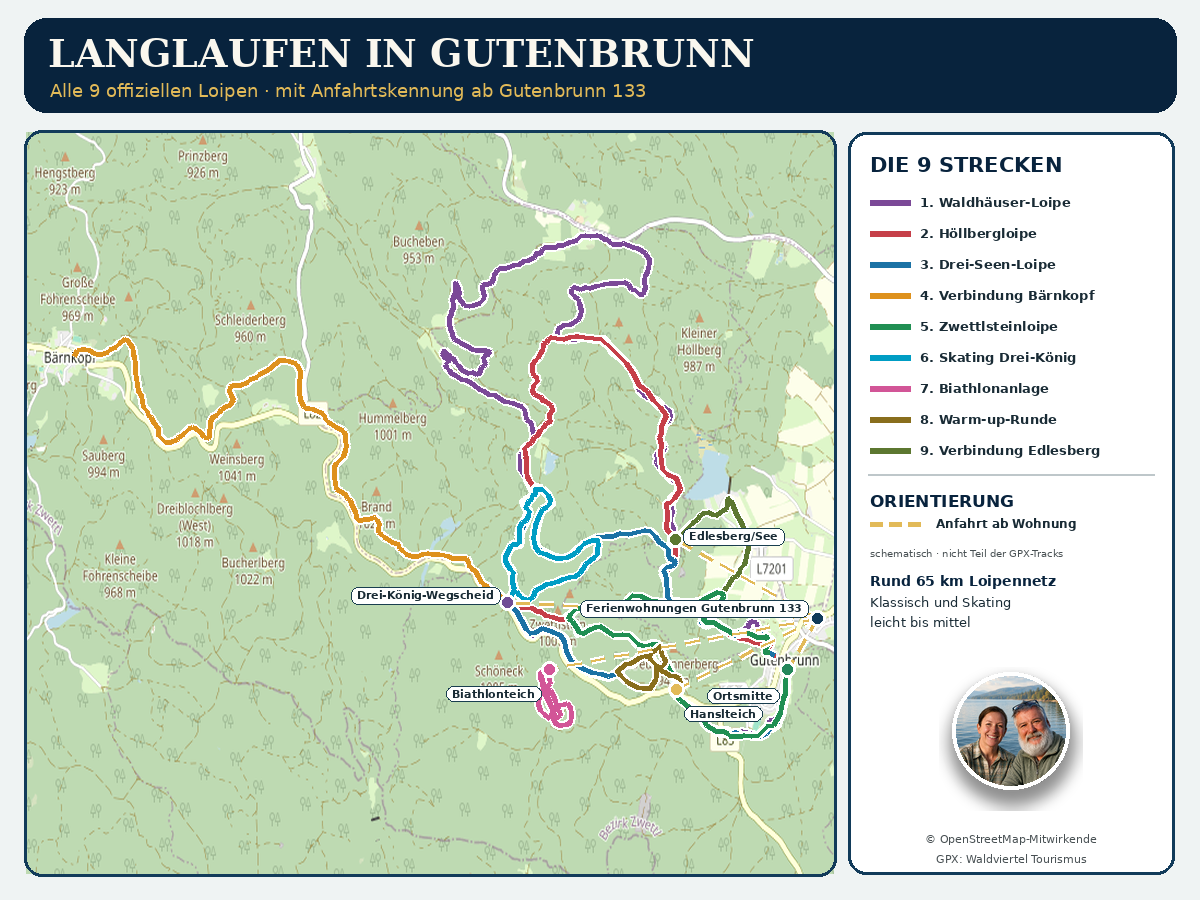
For guests staying in our vacation apartments, the cross-country ski trail area is especially convenient. The trailhead in the center of Gutenbrunn is very close to the Gutenbrunn Vacation Rentals 133. Additional entry points are located at Hanslteich, Drei-König-Wegscheid, Biathlonteich, and in Edlesberg. Our map shows all official GPX tracks, the main starting areas, and directions from your lodging.
Cross-Country Skiing in Gutenbrunn at a Glance
- Cross-country ski trail network: reported locally as approximately 65 kilometers
- Official routes: nine
- Difficulty: easy to moderate
- Running Styles: Classic and Skating
- Shortest route: Edlesberg Cross-Country Ski Trail 1.80 km
- Longest distance: Waldhäuser Cross-Country Trail, 20.44 km
- Entry Points: Town Center, Hanslteich, Drei-König-Wegscheid, Biathlonteich, and Edlesberg/See
- Elevation: mostly at an elevation of about 850 to 1,000 meters
- Current status: Check the local cross-country ski trail website before every outing
The individual distances listed should not simply be added together to calculate the total length of the trail network. Several trails share the same sections between Gutenbrunn, Hanslteich, Zwettlstein, and Edlesberger Höhe. Therefore, the sum of the trail lengths is greater than the actual length of the trail network.
A Comparison of All Cross-Country Trails in Gutenbrunn
| Cross-country ski trail | Length | Difficulty | Style | Home |
|---|---|---|---|---|
| Hanslteich Warm-up Lap | 2.05 km | slightly | classical | Hansl pond |
| Zwettlstein Cross-Country Ski Trail | 6.84 km | slightly | classical | Gutenbrunn Town Center |
| Three Lakes Trail | 10.89 km | slightly | classical | Gutenbrunn Town Center |
| Höllberg Trail | 13.38 km | slightly | classical | Gutenbrunn Town Center |
| Waldhäuser Cross-Country Trail | 20.44 km | medium | classical | Gutenbrunn Town Center |
| Edlesberg Cross-Country Ski Trail | 1.80 km | slightly | classical | Edlesberg/See |
| Bärnkopf Cross-Country Ski Trail | 7.84 km | slightly | classical | Three Kings Crossroads |
| Drei König Skating Rink in Wegscheid | 4.06 km | slightly | Skating | Three Kings Crossroads |
| Skating Loop at the Biathlon Facility | 2.80 km | slightly | Skating | Biathlon Pond |
The information is taken from the respective official tour descriptions. Weather, trail conditions, and local route variations may alter the actual nature of a tour. On-site signage and closures always take precedence.
Which cross-country ski trail is right for which guest?
If you're trying cross-country skiing for the first time, you should start with a short, manageable route. Experienced skiers, on the other hand, can choose longer loops or combine several sections.
For beginners and to warm up
The Warm-up lap at Hanslteich At 2.05 kilometers, it’s the ideal first choice. It’s perfect for learning the classic technique, testing your equipment, and getting in a short workout. The skating loop at the biathlon facility is also compact, but it does require a basic skating technique.
For an enjoyable morning walk
The Zwettlstein Trail offers an easy-to-follow route. It starts off with a mostly gentle climb, then heads back to Gutenbrunn. The Three-Lakes Trail is longer and offers particularly varied scenery. It passes Hanslteich, Stifterteich, and Lake Edlesberg over.
For endurance cross-country skiers
The Höllberg Trail connects long stretches of forest, granite boulders, and several prominent landmarks in the Gutenbrunn cross-country skiing area. The Waldhäuser Trail is even longer and more varied. Its 20.44 kilometers, numerous climbs, and longer descents require good physical conditioning and a solid classic technique.
For athletic skating
The skating track at Drei-König-Wegscheid offers a wide, groomed area for free-style skating. Another training option is located at the biathlon facility near the biathlon pond. Both trails are officially classified as easy. Skating itself is nevertheless more technically and physically demanding than the more relaxed classic gliding style.
For connections to Edlesberg and Bärnkopf
The Edlesberg cross-country ski trail provides access to the area around Lake Edlesberg. The connection to Bärnkopf largely follows a former railroad right-of-way through the Weinsberg Forest. Neither of these routes is a typical loop. Therefore, the return route, direction of travel, and possible pickup arrangements should be clarified in advance.
Cross-Country Skiing in Gutenbrunn: The Nine Trails in Detail
1. Warm-up Lap at Hanslteich
The Hanslteich Warm-up Lap This is the shortest classic loop trail in the Gutenbrunn network. It is officially 2.05 kilometers long and, according to the trail description, takes about 29 minutes to complete. With only minor elevation changes, it makes for a good training route.
If possible, the slope may be supplemented with artificial snow. However, this does not guarantee continuous operation. Here, too, you should check the current operating status.
2. Zwettlstein Cross-Country Trail, Gutenbrunn
The Zwettlstein Cross-Country Trail, Gutenbrunn It is 6.84 kilometers long and is rated as easy. Starting from the town center, it runs past the Hanslteich to the Zwettlstein. From there, a long, gentle descent takes you back to Gutenbrunn via the Edlesberger Höhe.
This circuit is a good next step after the warm-up course. Because of the downhill section, you should already be comfortable with braking, changing lanes, and maintaining control.
3. Gutenbrunn Three-Lakes Cross-Country Trail
The Gutenbrunn Three-Lakes Cross-Country Trail It connects Hanslteich, Stifterteich, and Edlesberger See over a distance of 10.89 kilometers. This varied loop trail starts in the town center and takes riders along forest trails, up hills, and down longer descents.
It is officially considered an easy hike, but with an elevation gain of 181 meters, it requires a solid level of basic fitness. For guests staying at the inn, it’s a wonderful opportunity to explore several typical winter landscapes around Gutenbrunn in a single hike.
4. Höllberg Cross-Country Trail, Gutenbrunn
The Höllberg Cross-Country Trail in Gutenbrunn is 13.38 kilometers long. It winds through quiet forest paths, past impressive granite boulders, and over the Höllberg. Hanslteich, Stifterteich, and Edlesberger See are also located along the route.
Although the difficulty is officially rated as “easy,” the route includes a total of 208 meters of elevation gain on the ascent and 232 meters of elevation loss on the descent. Endurance and solid downhill technique are essential for this roughly three-hour hike.
5. Waldhäuser Cross-Country Trail, Gutenbrunn
The Waldhäuser Cross-Country Trail in Gutenbrunn This is the main classic loop in the cross-country ski area. Spanning 20.44 kilometers, it connects Hanslteich, Zwettlstein, Stifterteich, Lupinendamm, Waldhäuser, Höllberg, and Edlesberger See.
It is the only one of the nine routes that is officially classified as intermediate. With an elevation gain of about 283 meters on the ascent and 307 meters on the descent, it’s a true endurance hike. Be sure to plan ahead by allowing plenty of time, bringing plenty of drinks, having enough energy reserves, and wearing appropriate winter clothing.
6. Edlesberg Cross-Country Ski Trail
The Edlesberg Cross-Country Ski Trail It leads from the Edlesberg/See area through open meadows to the Edlesberger Höhe. At 1.80 kilometers, it is a short route, but it offers a different view of the landscape than the main trails, which are mostly forested.
This section is suitable as an access route to the Gutenbrunn network or as a supplement when there is sufficient snow. Since this route is not a closed loop, you must plan your return trip in advance.
7. Bärnkopf Connecting Trail
The VBärn Cross-Country Ski Trailhead It starts at the Drei-König-Wegscheid. The route runs 7.84 kilometers, mostly along the former railroad right-of-way, toward Bärnkopf. The minimal elevation changes allow for a steady, classic pace.
The official GPX track is not set up as a closed loop. Our detailed map follows only the official route and does not include any made-up return route. For this route, you’ll need to arrange transportation back or pick-up before the start.
8. Drei König Skating Track in Wegscheid
The Drei König Skating Rink in Wegscheid is a 4.06-kilometer loop trail. The wide, groomed trail is ideal for free skating and for intense training sessions in the Weinsbergerwald.
The trailhead is at the Drei-König-Wegscheid cross-country ski junction. Beginners should start by practicing the skating motion slowly and leaving plenty of room for other skiers.
9. Skating at the Gutenbrunn Biathlon Facility
The Skating session at the Gutenbrunn Biathlon Facility starts at the biathlon pond. The official loop is 2.80 kilometers long and has an elevation gain and loss of 29 meters each.
The facility is a sports training venue and not a tourist biathlon program that automatically provides instruction or shooting sessions. Please note the current operating status and all on-site notices.
Comprehensive GPS Map for Cross-Country Skiing in Gutenbrunn
Our map shows the nine official GPX tracks in different colors. Because several routes use the same sections, some lines overlap. The map is intended to provide a general overview and does not replace the detailed maps in the individual posts.
In addition, the Gutenbrunn 133 vacation rentals and the main entrance areas are marked. The gold dashed line indicating the route is for orientation purposes only. It is not part of the official GPX tracks and no street-level navigation.
For specific tour information, we recommend opening the corresponding detailed map. There, you can more easily see the route, tour details, GPS coordinates, and points of interest.
Access from the Gutenbrunn vacation rentals
Our vacation rentals are located in 133 Gutenbrunn, 3665 Gutenbrunn. The town center—and thus the starting point for several classic loops—is right nearby. Depending on snow conditions and the route you choose, a short drive is required to reach Hanslteich, Drei-König-Wegscheid, Biathlonteich, or Edlesberg.
Park only in designated areas. Keep access routes clear for cross-country ski trail maintenance vehicles, snow removal equipment, and emergency vehicles. In winter road conditions, appropriate tires and defensive driving are essential.
Trail Conditions, Snow Conditions, and Season
Cross-country skiing in Gutenbrunn depends on natural snow conditions, temperature, and trail grooming. Even if a GPX file is available, that doesn't mean the trail is currently open or groomed. Check the Current cross-country trail conditions in Gutenbrunn.
The local website provides information about groomed classic cross-country trails, skating areas, connecting trails, and other winter activities. Signs at the trailheads and instructions from trail staff always take precedence. In strong winds, icy conditions, fog, or heavy snowfall, being in the forest can be dangerous.
Trail Fees and Equipment Rentals
For the 2025/26 season, the most recent prices announced were 5 euros for a day pass and 15 euros for a week pass. Children 15 and under were admitted free of charge. These prices are subject to change for the upcoming winter season. Therefore, please check the local website for current prices.
There is a ticket machine at Hanslteich. According to local sources, it accepts only coins and does not give change. Other ticket locations were listed as the Marschall Stuben cross-country ski lodge and the Seewolf Guesthouse.
Equipment rentals are also available in Gutenbrunn and Edlesberg. Please contact the listed businesses directly to inquire about availability, hours of operation, and suitable sizes.
Rules for Getting Along Well on the Cross-Country Ski Trail
- The cross-country trails may be used exclusively with cross-country skis.
- Pedestrians, snowshoers, and Dogs do not belong on the groomed trail.
- The specified direction of travel must be followed.
- When passing, follow these rules: stay to the right, pass on the left, and keep a safe distance.
- After a fall or during a break, the trail must be cleared quickly.
- Downhill sections, as well as trail and road crossings, require special caution.
- Trash will be picked up again.
- Do not leave the marked cross-country trails.
- Please be aware of when it gets dark. There is no automatic final check in the evening.
Being considerate doesn't just protect other cross-country skiers. It also helps preserve the groomed trails and avoid unnecessarily disturbing wildlife in the winter.
Tips for Your Cross-Country Skiing Day
Don't choose a tour based solely on the number of kilometers. Elevation gain, snow conditions, wind, visibility, and your personal skill level all affect how strenuous the tour will be. An easy 13-kilometer loop can be more strenuous in soft, fresh snow than a shorter route on a well-packed trail.
Start slowly and plan for breaks. On longer runs, bring a drink, a small energy snack, and an extra layer of dry clothing. A fully charged cell phone is also part of your basic gear.
If you're using new equipment, it's best to test your bindings, boots, and skis first during a warm-up lap. When skating, pay special attention to your range of motion and the designated skating lanes. Double tracks for classic-style skiing must not be damaged by skating strides.
Frequently Asked Questions About Cross-Country Skiing in Gutenbrunn
How many cross-country ski trails are there in Gutenbrunn?
The official regional guide lists nine trails: five classic loop trails or main routes, two connecting trails, and two skating trails. Several trails share certain sections.
Which cross-country ski trail is best for beginners?
The short warm-up lap at Hanslteich is the best way to get started in classic cross-country skiing. Anyone who wants to try skating should already have some basic knowledge or seek professional instruction.
Which is the longest cross-country ski trail?
At 20.44 kilometers, the Waldhäuser Trail is the longest official loop. It is classified as intermediate and requires good stamina and solid technique.
Can I start right at the vacation rentals?
The Gutenbrunn 133 vacation apartments are located very close to the trailhead in the town center. Whether direct access on snow is possible depends on snow removal, trail grooming, and the current route. Please use only the marked trailheads.
Are the cross-country ski trails always open?
No. Trail openings and grooming depend on snow conditions, the weather, and the work done by the trail service. Check the local trail report on the day of your visit and be aware of any closures.
Can I bring my dog on the cross-country ski trail?
No. According to local information, dogs are not allowed on the Gutenbrunn cross-country trails. Pedestrians and snowshoers are also not permitted to use the cross-country trails.
Where can I get a cross-country ski trail map?
The cross-country ski trail map is available at participating businesses and can be accessed via the official cross-country skiing website. Our overview map supplements this map by showing the location of the Gutenbrunn 133 vacation rentals.
Our conclusion: A variety of winter activities right on our doorstep
Cross-country skiing in Gutenbrunn offers a trail to suit almost every skill level. Short practice loops, leisurely classic-style tours, challenging skating trails, and long forest loops are all located close to one another. The combination of peaceful natural surroundings, easily accessible starting points, and the opportunity to gradually increase the difficulty of the tours is particularly appealing.
Comments are closed, but trackbacks and pingbacks are open.