


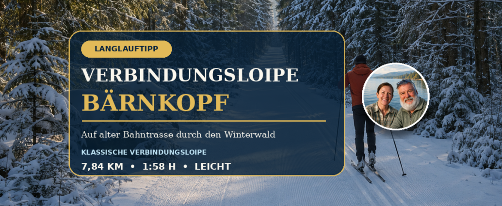
Cross-Country Skiing on an Old Railroad Right-of-Way
The Connecting Cross-Country Ski Trail Bärnkopf leads from the Drei-König-Wegscheid at Gutenbrunn A quiet, gently undulating trail heading toward Bärnkopf. For 7.84 kilometers, it runs mostly along the former railroad right-of-way through the wintry Weinsbergerwald. That’s precisely why it’s a great choice for anyone looking for a smooth, classic cross-country skiing experience surrounded by nature.
From our vacation rentals in Gutenbrunn, you can reach the trailhead after a short drive. The trail itself is designed as a connecting route. Therefore, please plan your return trip and check the current direction of the tracks, snow conditions, and whether the trail is open before you set out.
Bärnkopf Cross-Country Ski Trail at a Glance
- Route: 7.84 km
- Walking time according to the official tour: about 1 hour and 58 minutes
- Difficulty: slightly
- Promotion: 67 meters of elevation gain
- Relegation: 76 meters of elevation gain
- Elevation: 943 to 1,002 meters
- Running style: classical
- Start: Three Kings Crossroads
- Character: Cross-country ski trail on a former railroad right-of-way
- Direction: Connection toward Bärnkopf
The official „easy“ rating fits well with the even nature of the trail. Nevertheless, good physical conditioning, confident trail navigation, and winter-appropriate gear are necessary. Even an easy trail can become more challenging in the event of fresh snow, wind, icy conditions, or poor visibility.
Route of the Bärnkopf Cross-Country Ski Trail
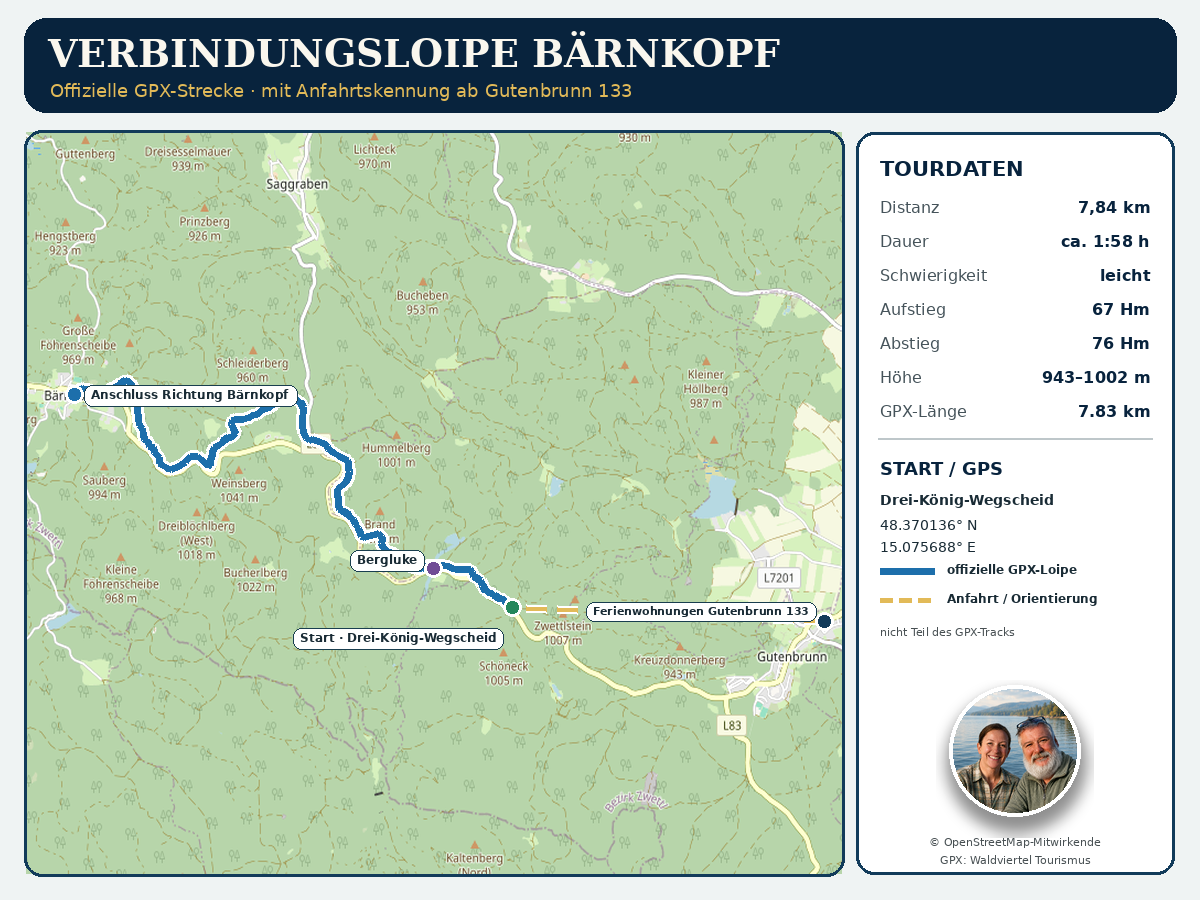
The official GPX track starts at the Three Kings Crossroads west of Gutenbrunn. From there, the Bärnkopf connecting trail heads toward Bärnkopf. For long stretches, the trail follows the route of the former narrow-gauge railroad. This explains its pleasantly even course with only slight changes in elevation.
Shortly after setting out, you’ll find yourself immersed in the Weinsberger Forest. The route winds through a tranquil forest landscape featuring spruce trees, small clearings, and the granite formations typical of the region. In this section, the focus isn’t on intense, athletic pace. Instead, a calm rhythm develops that’s well-suited to a longer, classic run.
A prominent landmark along the trail is the Mountain Pass. From there, the cross-country trail continues through the expansive forest area. The official GPX track ends to the west of this point at the junction leading toward Bärnkopf. This connection is therefore particularly well-suited for visitors who are planning a longer cross-country ski trip or who wish to combine the Gutenbrunn trail network with the Bärnkopf area.
Important Note Regarding the Official GPX Track
The official tour website lists “Drei-König-Wegscheid” as both the start and finish. However, the GPX track provided there is not a closed group. It is approximately 7.83 kilometers long and ends several kilometers west of the starting point, in the direction of Bärnkopf.
Our GPS map shows exactly this official trail. We have not added a return route or made up any part of the trail. The gold dashed line simply indicates the direction from the Gutenbrunn 133 vacation rentals to the trailhead. It is expressly not part of the GPX track and is not a substitute for in-car navigation.
Why the old railroad right-of-way is ideal for cross-country skiing
Former railroad right-of-ways were designed with gradients as even as possible. Today, the Bärnkopf cross-country ski trail benefits from this. Long, quiet stretches make it easier to find a steady rhythm. Those who want to improve their technique can focus more on the classic diagonal stride, clean gliding, and consistent pole use.
However, the low technical difficulty does not mean that the route is short. At just under eight kilometers one way, the route requires a solid level of basic fitness. On top of that, you’ll need to factor in the return trip or a pre-arranged ride back. Therefore, don’t just count on the official running time—take the entire logistics of the trip into account.
For active guests, the trail can be part of a longer cross-country skiing day. Runners who prefer a more leisurely pace can choose a shorter section and turn back in time. The key is to realistically assess your stamina and the available daylight.
Who is the Bärnkopf connecting trail suitable for?
The Bärnkopf connecting trail is well-suited for classic-style cross-country skiers who can already cover a few kilometers confidently on the trail. Because of its gentle incline, it’s also suitable for less experienced skiers. For a very first attempt, a shorter loop near Gutenbrunn is usually more practical.
If you'd like to ease into it first, you'll find at the Drei-König-Wegscheid Skating Rink another access point to the winter sports area. For varied tours, you can also explore the Gutenbrunn Three-Lakes Cross-Country Trail and the Höllberg Cross-Country Trail in Gutenbrunn to.
This connection is especially appealing to people who appreciate the following:
- quiet wooded areas instead of heavily used training facilities,
- classic cross-country skiing on a smooth track,
- longer endurance segments with moderate elevation changes,
- historic trails and the history of the old railroad line,
- a connection between the Gutenbrunn and Bärnkopf cross-country skiing areas.
Directions to the Bärnkopf Cross-Country Ski Trail
The starting point for our guests staying at the inn is the Gutenbrunn Vacation Rentals 133, 3665 Gutenbrunn. The official starting point is at the Drei-König-Wegscheid, west of town. The coordinates for the GPX start are:
48.370136° N, 15.075688° E
On the attached GPS map, you’ll see the vacation rentals marked with their own icons. A gold dotted line schematically connects the location to the starting point. This line is for spatial orientation only. For your actual route, please use an up-to-date GPS navigation system and be aware of winter driving conditions.
Before you set out, it’s a good idea to check the local cross-country ski trail report. The municipality’s official website provides information about the season, opening times, and the condition of the trail network. Park only in designated areas and keep access roads clear for snowplows and emergency vehicles.
Current Trail Conditions, Fees, and Rules
Cross-country skiing is a nature-based sport in Gutenbrunn. Whether a trail can be opened depends on snow depth, temperature, wind, and trail conditions. Therefore, please check the Current cross-country trail conditions in Gutenbrunn. Statistics from a previous season are no guarantee of performance in the upcoming season.
The municipality's website recently listed daily and weekly passes for the cross-country ski trail network. The prices listed there are subject to change. Therefore, please refer to the most up-to-date information available on site. According to local information, a ticket machine is located at the Hansl pond and accepts coins.
There are a few simple rules for getting along well:
- Follow the signs indicating the direction of travel.
- Please use only cross-country skis on the trail.
- Pedestrians and snowshoers must stay off the trail.
- Dogs do not belong on the cross-country ski trail.
- Keep a safe distance from oncoming traffic or when passing other vehicles.
- Adjust your pace and the length of your ride based on visibility, the trail conditions, and your fitness level.
- Please take your trash with you.
On connecting trails, the return trip may take longer than expected. Therefore, you should pack a fully charged cell phone, a drink, and a small energy snack. If it’s cold, it’s also a good idea to bring an extra dry layer of clothing.
Practical Tips for a Great Day of Cross-Country Skiing
Don't start out too fast. The flat course makes it tempting to pick up speed right from the first few kilometers. A slow start will help you conserve your energy for the later part of the route and the return trip.
Classic cross-country skis should be suited to the current snow temperature. In changing conditions, well-maintained scale skis or skin skis are a straightforward choice. If you use waxed skis, you should carefully adjust the climbing zone to the temperature and snow conditions.
The time of day also makes a difference. In the morning, the trail is often firmer. After hours of sunshine, the snow can soften, while shaded sections of the forest remain cold and icy for longer. After a thaw, the trail may become icy the following morning.
Be considerate of slower riders. When passing, give a friendly warning and choose a spot where you have a clear view. When taking a break, stay on the side so the main trail remains clear.
Nature and railroad history along the cross-country ski trail
The historic rail line shaped Gutenbrunn and the forest region for many years. Today, the old rail line serves as a reminder of a time when timber, goods, and people were transported through the Waldviertel on the narrow-gauge railway. Anyone interested in learning more about this topic can find information in our article on Gutenbrunn Forest Railway Further background information.
In winter, the landscape changes dramatically. Snow muffles sounds, traces the contours of the granite boulders, and opens up new lines of sight between the trees. Despite its proximity to Gutenbrunn, the area feels very secluded in places. It is precisely this blend of history, forest, and physical activity that makes this route so special.
Please stay on the marked trail. Wild animals need peace and quiet during the cold season, and every time they have to flee, they expend valuable energy. Taking shortcuts through the forest not only harms nature but can also make it difficult to find your way.
Frequently Asked Questions About the Bärnkopf Cross-Country Ski Trail
How long is the Bärnkopf cross-country ski trail?
The official route description lists 7.84 kilometers. The downloaded GPX track measures approximately 7.83 kilometers. Minor differences result from rounding and the method used to analyze the GPS data.
Is the Bärnkopf connecting trail a loop trail?
No. The official GPX track is a route from the Drei-König-Wegscheid toward Bärnkopf. Although the tour page lists the same starting and ending points, the GPX route does not form a loop. Plan your return trip, pickup, or way back before you start.
Is the route suitable for beginners?
The trail is officially classified as easy and has only slight elevation changes. However, due to its length and the need to plan the return trip, it is less practical for first-time cross-country skiers than a short loop. Beginners should start by choosing a shorter trail or skiing only a manageable section of it.
Where does the Bärnkopf cross-country ski trail start?
The official GPX starting point is at the Drei-König-Wegscheid, at coordinates 48.370136° N and 15.075688° E. Our map also shows the route from the Gutenbrunn 133 vacation rentals.
Can I bring my dog on the cross-country ski trail?
No. According to local cross-country ski trail rules, dogs are not allowed on the trails. This protects the groomed trail, other skiers, and wildlife.
Where can I find the latest snow conditions?
Before setting out on your tour, check the latest information on the Gutenbrunn municipality’s website. Weather and trail conditions can change quickly. On-site signage and closures always take precedence.
Our Conclusion on the Bärnkopf Connecting Trail
The Bärnkopf connecting trail combines smooth classic-style cross-country skiing with the tranquil atmosphere of the Weinsbergerwald. The route along the former railroad right-of-way, the moderate inclines, and the connection toward Bärnkopf make it a beautiful endurance trail for a well-planned winter day.

Comments are closed, but trackbacks and pingbacks are open.