


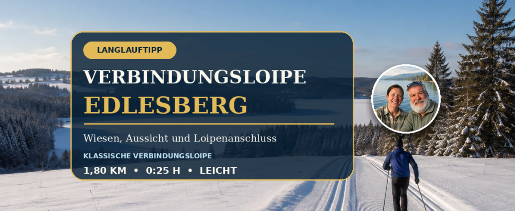
Short cross-country ski trail offers a connecting route Edlesberg with a view.
In addition, the Edlesberg cross-country ski trail runs from the Edlesberg/See area across open meadows.
In addition, the trail leads up to the Edlesberger Höhe.
In addition, the official tour description lists the distance as 1.80 kilometers, with an estimated walking time of about 25 minutes, and rates the difficulty as easy.
This short section connects the area near the Lake Edlesberg with the Gutenbrunn cross-country ski trail network.
What makes this trail special is its open landscape. While many cross-country trails around Gutenbrunn While it passes through dense forest, according to the official description, the connecting cross-country ski trail runs mostly through meadows.
This offers beautiful views of Edlesberg, Lake Edlesberg, and the surrounding forested hills.
This trail is of interest to guests staying at the Gutenbrunn vacation apartments. It’s ideal if you’re planning a short cross-country skiing session. Alternatively, the trail serves as a gateway to other sections of the cross-country ski trails.
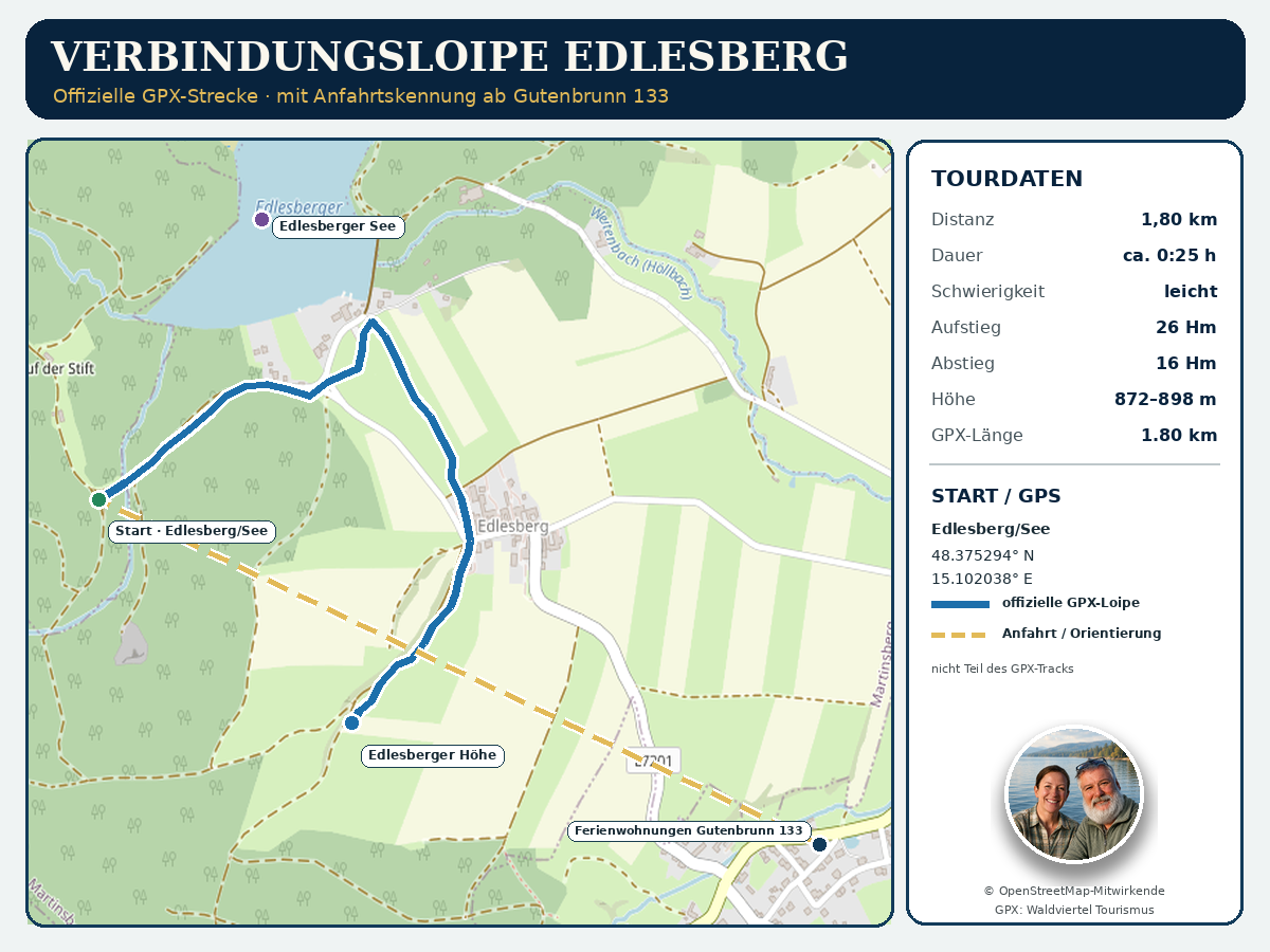
Our GPS map shows the official trail. It also displays a gold dashed line indicating the route starting from the address "Ferienwohnungen Gutenbrunn 133." However, this guide line is not part of the official trail.
The Connecting Cross-Country Trail at a Glance
- Start: Edlesberg/See, parking lot at the Seewolf Guesthouse
- Official Destination: Gutenbrunn
- GPX file route: Edlesberg/See to Edlesberger Höhe
- Trail type: Connecting trail, not a loop trail
- Technique: classic cross-country skiing
- Distance according to the current official tour website: 1.80 kilometers
- Official duration: approximately 25 minutes
- Difficulty: easy
- Fitness Level: 1 of 6
- Ascent: 26 meters in elevation
- Descent: 16 meters in elevation
- Lowest point: 872 meters
- Highest point: 898 meters
- Technically calculated GPX length: approximately 1.80 kilometers
- GPX track points: 40
The route is short, but it's not completely flat.
From the Edlesberg/See area, it climbs through meadows to the Edlesberger Höhe.
Anyone who uses the Edlesberg connecting trail in the opposite direction will naturally experience the elevation gain differently than when traveling in the official direction.
Why is 2.5 kilometers sometimes mentioned?
The local Gutenbrunn cross-country trail map lists the Edlesberg connecting trail as 2.5 kilometers long. In addition, the official tour page of Waldviertel Tourism lists it as 1.80 kilometers. The accompanying GPX file also technically measures about 1.80 kilometers.
For our GPS map and detailed tour data, we therefore use the current official GPX data for the Edlesberg cross-country ski trail, which is 1.80 kilometers long. Any discrepancy in local information may be due to a different boundary, an additional connection, or a rounded total length. Since there is no clear, up-to-date GPX track available for this, we do not invent any additional sections of the route.
Who is this route suitable for?
The connecting trail is particularly well-suited for hikers.
It is also aimed at mountain bikers.
- Beginners in cross-country skiing with solid basic technique
- People Returning to Exercise for a Short Workout
- Guests who would like to explore the Edlesberg area
- Experienced cross-country skiers as a link to longer trails
- Older, athletic guests with cross-country skiing experience
- Families with children who can brake and steer safely
- Cross-country skiers who prefer open meadow trails
The “easy” rating does not mean that no caution is required. Wind, snowdrifts, and ice can significantly alter open sections of the trail. Even a short climb can become more strenuous if the trail is soft or there is a headwind.
Route from Edlesberg to Edlesberger Höhe
The official tour begins in the Edlesberg/See area at the parking lot of the Pension Seewolf. The first GPX waypoint is at 48.375294 degrees north and 15.102038 degrees east.
From the starting area, the trail first leads through the outskirts of Edlesberg and then across open meadows. The trail climbs toward Edlesberger Höhe. The last point in the current GPX file is at 48.371105 degrees north and 15.109849 degrees east.
Start at Lake Edlesberg
The trailhead near the lake offers particularly scenic views. Depending on the temperature, snow conditions, and amount of sunlight, the ground in this area may vary in firmness. Before setting out, check the trail conditions and the direction of travel.
Lake Edlesberg is a beautiful setting in winter. However, a solid layer of snow or ice should never automatically be assumed to be safe to walk on. The cross-country ski trail runs along the shore; walking on the lake is not part of the route.
Across the open meadows
The surroundings are clearly visible from the meadows. At the same time, these areas are more exposed to wind and sun than forested sections. Drifts may form after fresh snowfall. Hard or icy patches may develop after mild days followed by frost.
Use the uphill section to establish a steady rhythm. Short strides, a clean push-off, and stable pole use conserve energy. If you pick up the pace too early, you’ll quickly lose your technique on soft trails.
Interchange at Edlesberger Höhe
The GPX file ends in the Edlesberger Höhe area. There, the trail functions as a connecting trail: this section serves not only as a short, standalone route but also as a link within the larger trail network.
To find out which subsequent trails are currently groomed and open, check the daily trail report. The GPS map intentionally shows only the official 1.80-kilometer route and does not include any assumed extensions.
Not a round trip—plan your return route in advance
The connecting trail is not a loop. If you want to ski only this section, you'll need a way to get back. Depending on the current trail route, this may mean:
- to run back along the same cleared section
- to switch to another open cross-country ski trail
- to coordinate the return trip with an escort
- to use the route as part of a longer trip
Please observe the designated direction of travel. Not every trail may be used in both directions without restriction. Signage and instructions from the trail service take precedence.
Directions from Gutenbrunn Vacation Rentals 133
The Gutenbrunn 133 vacation rentals are located east of the connecting cross-country ski trail. On our map, the accommodation is clearly marked at 48.368830 degrees north and 15.124330 degrees east. A golden dotted line indicates the direction to the official trailhead at Edlesberg/See.
This label means:
- Starting point for guests staying at the property: Gutenbrunn 133 Vacation Apartments
- Directions to the starting point at Edlesberg/See
- Directions from the lodging to the trailhead
- Not part of the official GPX track
- No designated road, walking, or ski route
The official tour website lists “Edlesberg” or “Edlesberg/See” as the destination. You should check before leaving to see if the parking lot at Pension Seewolf is accessible and available for free use in winter. Be sure to follow winter driving guidelines, snow removal schedules, and local signs.
Anna and Herbert are happy to help guests find their way around and choose a suitable cross-country skiing trail.
Classic cross-country skiing technique on the connecting trail
The course is designed as a trail for classic-style cross-country skiing. Skiers generally ski parallel to each other in two groomed tracks. Depending on their equipment, they push off using a double-poling technique, skins, climbing wax, or another climbing aid.
The following points are helpful for a gentle ascent:
- Tilt your upper body slightly forward
- Shift your weight completely onto the push-off ski
- Take short, controlled steps
- Use your poles close to your body
- Do not stand on the tips of your skis
- Slow down when traction decreases
Skating strides must not damage the classic double track. If there is no designated skating area next to the track, skiers must continue using the classic technique.
Check the current cross-country trail conditions
A GPX file shows the geographical route, but not the current conditions. A lack of snow, thawing, ice, wind, forestry work, and trail grooming can cause changes at short notice.
Before you begin, check the following:
- Is the Edlesberg connecting cross-country ski trail currently groomed?
- Is access permitted at Edlesberg/See?
- Which direction of rotation applies?
- Which connecting cross-country ski trails are open?
- Are there any snowdrifts or icy patches?
- Is the parking lot accessible?
- How are the weather and visibility changing?
The official Gutenbrunn cross-country ski trail website currently indicates that the season has ended and refers to the 2026–27 winter season. Once winter operations begin, the current trail report, the information signs, and the instructions provided by trail staff will take precedence. Date of this summary: August 17, 2026.
Recommended Equipment
For the connecting cross-country ski trail, we recommend:
- Classic cross-country skis in the appropriate length
- A climbing zone or trail grooming suited to the snow temperature
- Well-fitting cross-country ski boots
- Cross-country ski poles of the appropriate length
- Breathable clothing based on the layering principle
- windproof jacket
- Gloves
- Cap or headband
- Sunglasses or sports glasses
- Cell phone with a fully charged battery
- GPX file saved offline
- Beverage, protected from the cold
- personal medications
- small first-aid kit
In open meadows, protection from the wind is especially important. In sunny weather, the snow reflects light strongly; it’s a good idea to wear appropriate sunglasses and sun protection.
Safety and Behavior on the Cross-Country Ski Trail
Even on a short and easy route, the usual rules apply:
- Follow the specified direction of travel
- Stay in the right lane and pass on the left in a controlled manner
- When there is oncoming traffic, yield to local traffic
- Clear the track as quickly as possible after a fall
- Do not stop in areas with limited visibility
- Adjust your speed to the road surface and visibility
- Do not block access points
- Respect the barriers
- Provide assistance in the event of an accident
Dogs You are not permitted to enter the Gutenbrunn cross-country trails. Pedestrians, snowshoers, sleds, and other sports equipment are also not allowed on the cross-country trails. Use of the trails is at your own risk.
Is the cross-country ski trail suitable for older guests?
The short distance and the official “easy” rating make this route appealing to active older guests. Prerequisites include a solid cross-country skiing technique, good balance, and a realistic assessment of one’s current physical condition.
The open meadow section can be more challenging in windy conditions, on ice, or in soft snow. If you feel unsure, it’s best to start with a short, flat practice run or choose the Warm-up lap at the Hansl pond.
Cross-Country Skiing with Kids
Children can use this route if they are already confident walking, braking, and stopping on the regular trail. Adults should adjust the pace and duration to match the slowest member of the group.
Since this is not a round-trip route, the return route must be planned in advance. Children should not ride ahead on their own, especially at intersections and junctions.
Is the route accessible?
No. The connecting cross-country ski trail is not barrier-free. Snow, cross-country skiing technique, uphill sections, and changing weather conditions require agility and physical endurance.
This trail may not be used as a winter hiking trail. Depending on trail conditions, separate winter hiking trails are available for walks.
Trail Fee, Ticket, and Equipment Rental
The following prices were most recently set for the Gutenbrunn– cross-country ski trail network for the 2025–26 season:Bärnkopf Published:
- Day pass: 5 euros per person
- Weekly pass: 15 euros per person
- Children and teens up to age 15: free
According to official information, the ticket machine at Hanslteich accepts only coins and does not give change. Other ticket locations are listed at Marschall Stuben and Pension Seewolf.
Pension Seewolf is also listed as a cross-country ski rental shop. You should check directly in advance to see if the right equipment is available. Prices, hours of operation, and rental offerings are subject to change for the 2026/27 season.
Book a vacation rental directly
Would you like to explore the cross-country ski trails around Gutenbrunn and Edlesberg? Our vacation rentals offer plenty of space, peace and quiet, and personalized service from Anna and Herbert.
You can check availability and book your stay right here:
Additional Information
Official route description for the Edlesberg cross-country ski trail, including a GPX file:
https://www.waldviertel.at/touren/verbindungsloipe-edlesberg
Current cross-country ski trail report, trail map, and local rules:
Official description of Lake Edlesberg:
https://www.waldviertel.at/ausflug-freizeit/edlesberger-teich
Official Overview of Cross-Country Skiing in Gutenbrunn–Martinsberg:
https://www.waldviertel.at/ausflug-freizeit/langlaufen-in-gutenbrunn-martinsberg
Comments are closed, but trackbacks and pingbacks are open.